Last month, we had a holiday in Taranaki, from 12 to 19 November. We spent three days in New Plymouth where we did quite a lot of biking, and three days in Eltham, where we did bike a little but did mostly other activities.
On the way to New Plymouth, we decided to take the Surf Highway route, rather than the somewhat more direct road around the eastern side of “the mountain” – Mt Taranaki/Egmont. The coastal route is more scenic, and besides it was sunny on this side, and cloudy on the other.
We turned off the main road at Opunake and went down to the beach. There are some spectacular cliffs there that clearly show the layers of Mt Taranaki’s volcanic eruptions over time.
 |
| These layers were caused by successive volcanic eruptions |
 |
| A close-up of the layers (photo by John) |
 |
| The beach was empty apart from these people fishing (photo by John) |
As we got closer to New Plymouth, the cloud over Mt Taranaki mostly cleared, and by late afternoon, we had a great view on the peak from our “Urban Bach” where we have stayed a couple of times before.
 |
| Mt Taranaki shows its peak (photo by John) |
Day 2 – Coastal and Mangati Walkways
First off we wanted to bike along the Coastal Walkway. This is a wonderful, smooth, flat, wide path along the New Plymouth foreshore and beyond. We have biked this once before, in the pouring rain, early on in our re-start biking experience.
We parked the car near the port area, and headed off towards the Coastal Walkway.
 |
| The start of the Coastal Walkway – Paritutu in the background on the right (photo by John) |
It was a bit overcast and windy to begin with – quite cold actually – but the day gradually improved. The track seemed “shorter” than last time, but presumably that must just be because we were riding e-bikes this time. When we got to the Rewa Rewa bridge, we took some photos, but the mountain was all shrouded in cloud.
 |
| Te Rewa Rewa Bridge is reminiscent of both a breaking wave and a whale skeleton (photo by John) |
We carried on towards Bell Block, right to the end, then turned around and continued further up the Coastal Walkway. We arrived at the Taranaki Cycle Park, where there is a velodrome. We biked around the rim of the velodrome, but didn’t try the gate into it as we weren’t sure if that was OK. We should have checked the sign – it would have been fun to bike around it. Instead we biked down a track that went around the whole park – very smooth and nice riding.
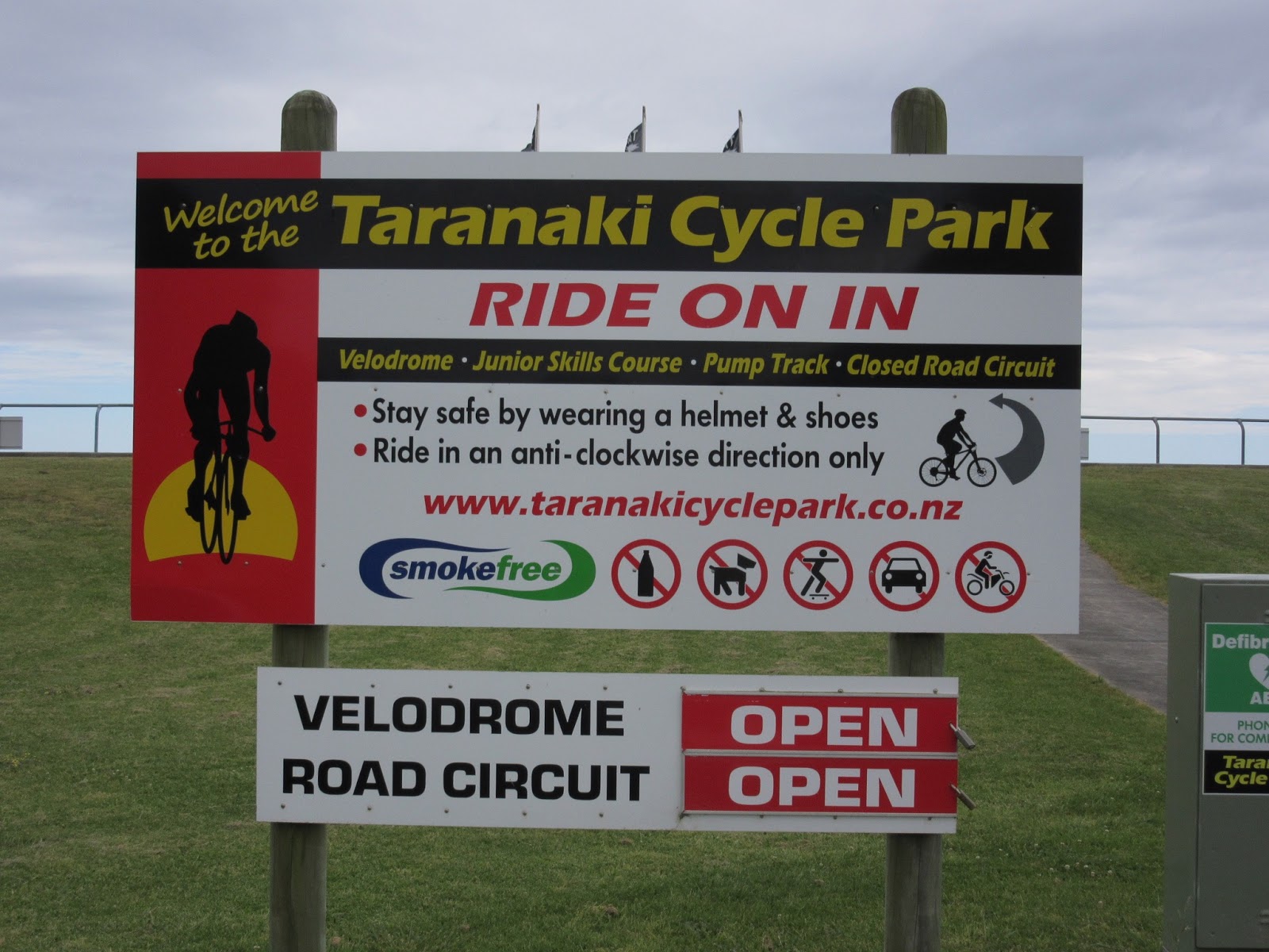 |
| Taranaki Cycle Park |
 |
| We biked around the rim of the velodrome (photo by John) |
There was also a junior mini road circuit, complete with traffic lights, roundabouts, and an obstacle course. We met a young boy who was charging around on his little bike. Totally confident and pretty skillful. We chatted with his Dad, and asked if it was OK to take a picture of him.
 |
| Young Kayde, aged very nearly five, was quite happy to pose for us |
We followed the walkway till the very end. There we stopped to look at some cliffs, and John pointed in the distance and said “that will be Waitara over there, I used to bike there every day (20 km each way) to work at the freezing works during the summer holidays”.
 |
| Looking towards Waitara (photo by John) |
After lunch at the White Pear Café in the Parklands shopping centre, we went back to the Coastal Walkway, and made a side trip onto the Mangati Walkway – very pretty, along a stream with several little red bridges leading to other streets.
 |
| The Mangati Walkway |
 |
| Cabbage trees in full flower (photo by John) |
 |
| The walkway can be accessed via pretty bridges across the Mangati Stream (photo by John) |
The walkway ended at De Havilland Drive which we explored a bit, as it was near the original airport where John’s father used to work as an aircraft engineer. Nearby, I spotted a NZ Cycle Trail sign saying "Taumarunui 170 km".
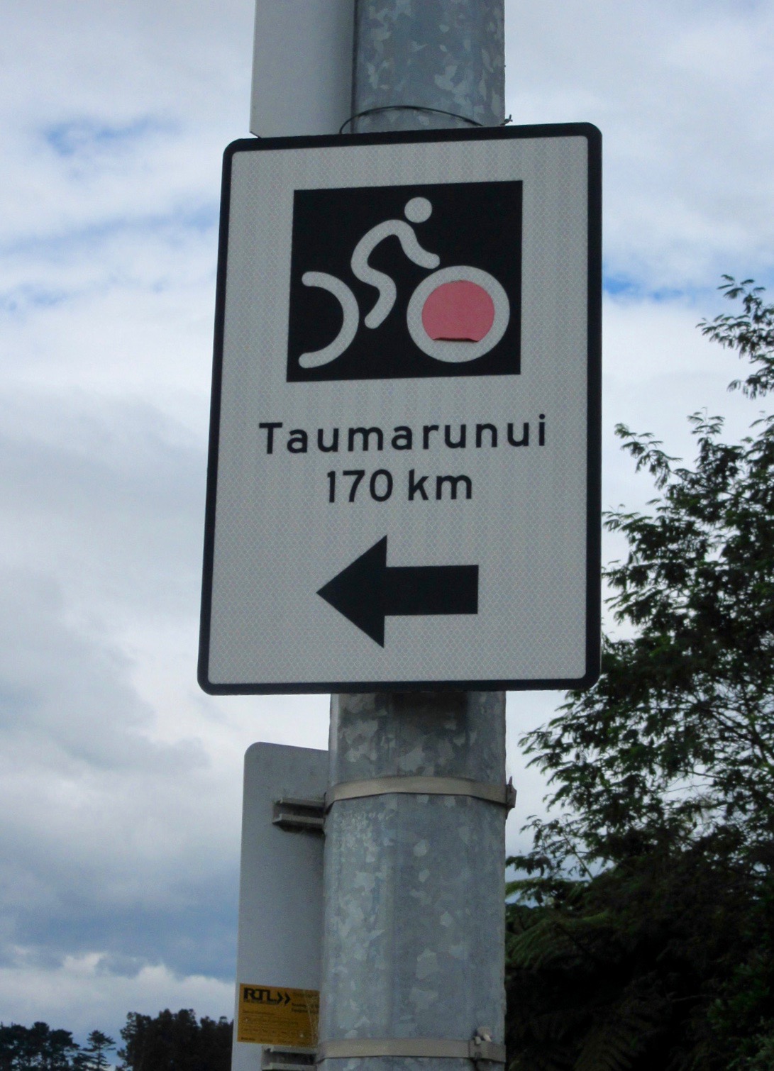 |
| Only 170 km to Taumarunui – no, I don’t think we’ll do that today … |
We went back to the track and made our way back to the Coastal walkway, diverting near the Te Rewa Rewa Bridge, to ride to Lake Rotomanu, a small pretty lake surrounded by beautiful trees. And near the bridge over the Te Henui Stream, I spotted a huge, magnificent pohutukawa tree, that I could not resist taking a photo of.
 |
| Lake Rotomanu (photo by John) |
 |
| A magnificent pohutukawa tree |
We headed back towards the car, but that was not the end of our ride, because John wanted to have a browse around Moturoa, the area where he spent much of his childhood.
We crossed the railway line and biked up to Peace Avenue, where we took photos of their former house. John wanted to re-live his boyhood, when he and his mates would take turns careering down the street in a soapbox trolley, so he coasted down the road a few times on his bike. He remembers with glee the screeching noise the steel lawnmower wheels made as he stopped by making the trolley skid sideways. He says that none of the neighbours ever complained about the noise.
 |
| The house in Peace Avenue |
 |
| Coasting down the street – no screeching steel wheels this time! |
We went down to Ngamotu beach where Mrs Mac from next door would frequently take John and his sister for a swim.
 |
| Ngamotu Beach |
 |
| There were four or five “nodding donkey” oil wells operating in Moturoa when John was young. Only a couple of non-operating ones are left now (photo by John) |
John used to mow the lawn for a man who was very particular about how his lawn looked. However, when some of the wells were closed down, an oil seep turned up on his lawn, spoiling the effect.
After a good look around John's old neighbourhood, we finally headed back to our cottage, were we were delighted to see “the mountain” without cloud cover.
 |
| A clear view of Mt Taranaki (photo by John) |
Day 3 – More New Plymouth pathways
Today we biked from our cottage, leaving the car “at home”. We headed off down Tukapa Street, and by meandering around various streets, we joined the Mangaotuku Walkway. Like many of the pathways, it follows a stream in one of the myriad gullies that are typical of the New Plymouth landscape, crosses roads and dives back into another bushy gully.
 |
| We biked from the cottage, leaving the car “at home” (photo by John) |
 |
| One of the exits and re-entries into the Mangaotuku Walkway (photo by John) |
 |
| Along the Mangaotuku Walkway (photo by John) |
I must admit that my sense of direction is fairly useless, and the New Plymouth walkways network has me completely stumped. Of course John, having grown up in New Plymouth, sort of knows his way around, though the walkways are a new feature since those days. So I just happily follow wherever he leads me … But be warned – some of the place names I mention in this blog post may well be quite incorrect.
The plan for the day was to explore a couple more walkways, and since they started from the Coastal Walkway, that’s where we headed. But first, we stopped at Manou’s Café by the port, for coffee and muffins. This place is quirky and exuberant, with flags decorating the ceiling, a deck with a “drunken sailor” in a hammock, and sparrows that are incredibly bold, waiting for you to turn away so they can steal crumbs from your plate.
 |
| Manou’s Café (photo by John) |
 |
| A “drunken sailor” kips in a hammock above the deck (photo by John) |
 |
| “How dare you try to shoo me away!” (photo by John) |
Along the Coastal Walkway we stopped to talk to a guy who was making stone stacks on the big rocks lining the path. He told me he did not use any adhesive – he just uses the small dimples and bumps in the stones to position and carefully balance them on top of each other. Quite astonishing. When we came back along there later in the day, he had made several wondrous sculptures in this way.
 |
| A day’s worth of stone stacks |
Near the Wind Wand, we took a path that went under the road and railway line into the town centre and uphill towards the start of the Huatoki Walkway. Very pretty alongside a stream, and again, crossing roads and gullies and confusing me in a big way as to where we were.
 |
| On the Huatoki Walkway (photo by John) |
 |
| A pretty little waterfall (photo by John) |
At one of the road crossings, we biked down some streets, as John wanted to go to Brooklands Park to look at the 2000-year-old puriri tree. The tree was about 100 metres in from one of the entrances to Pukekura Park.
 |
| This puriri tree (Vitex lucens) is reputed to be 2000 years old (photo by John) |
 |
| Looking up into its canopy |
As cycling is not permitted in the park, we left and biked on in the streets. We found our way to the top end of the Te Henui Walkway, so we followed that. Very pretty also.
 |
| The Te Henui Stream (photo by John) |
This track ended up back at the Coastal Walkway, right near a reserve where we found a place to have lunch – a container café called “Petit Paris” run by a French couple, where I was greeted with a cheerful “Bonjour Madame!”. We enjoyed our coffee and eats at one of the tables which dotted the lawn.
 |
| Café “Petit Paris” (photo by John) |
 |
| Relaxing after lunch (photo by John) |
After this, we biked back towards the city centre, to go back to the cottage, but first we had a look at the outside of the Len Lye Centre. The building, which was opened in July 2015, is very impressive – all shiny and curvy, giving amazing reflections of the White Hart Hotel opposite. A neat juxtaposition of the old and the very new.
 |
| The White Hart Hotel is reflected in the Len Lye façade (photo by John) |
 |
| The White Hart Hotel (photo by John) |
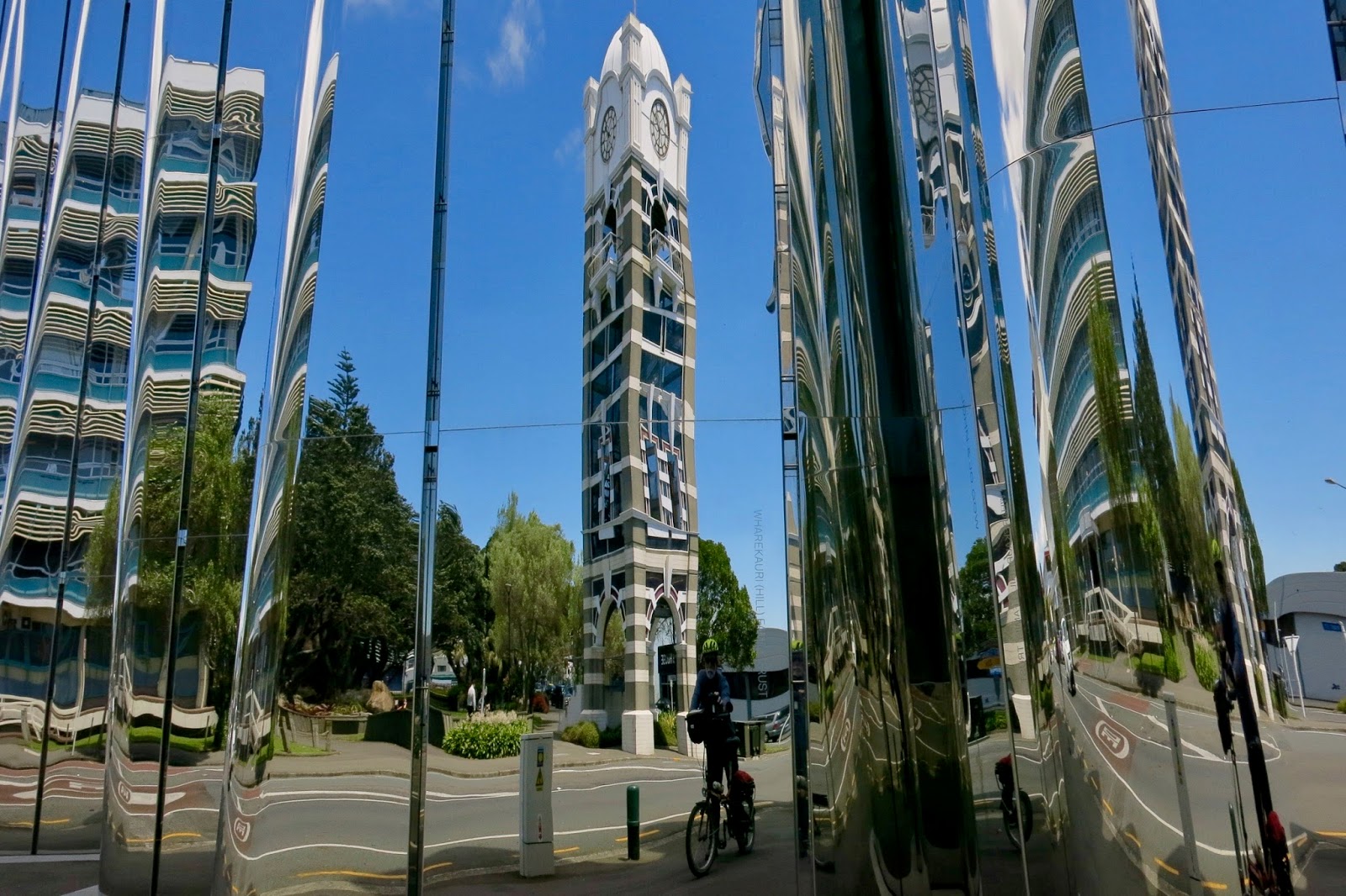 |
| Reflection of the clock tower (photo by John) |
NZ artist Len Lye (1901-1980) was a pioneer of experimental film and kinetic sculpture. The Wind Wand on the waterfront is one of his works.
We went back to the cottage to leave the bikes and collect the car, and went back into town for a bit of a wander. Apart from shops – which really don’t excite me very much – we saw some interesting murals.
 |
| A gigantic tui (photo by John) |
 |
| A mural in progress in a narrow lane between buildings (photo by John) |
 |
| Two very different styles together (photo by John) |
 |
| How about this for a bike? (photo by John) |
Finally, we drove to the far end of town to have a look at Paritutu, the Sugar Loaf Islands, and Back Beach. The islands are the remains of an ancient extinct volcano crater.
 |
| Paritutu Rock (photo by John) |
 |
| Three of the seven Sugar Loaf Islands. You can walk across when the tide is out (photo by John) |
 |
| Back Beach is a great surfing beach (photo by John) |
No comments:
Post a Comment