Thursday 25 September 2014

Folding Goldies ride - Waikanae to Peka Peka


Yesterday we went on another Folding Goldies ride. This time, the plan was to take the train to Waikanae and ride to Peka Peka, and back, and return by train before the 3pm deadline (so we could use our Gold Cards, and travel for free).

We had a fine-ish day for it, though quite windy. But compared to the rain, hail and bitterly cold southerly gales we had on Monday, this was bliss. We boarded the train at Takapu Road, and were met by Alastair – the instigator of the Folding Goldies – and Daryl. John B would meet us in Waikanae.

It takes an hour to get to Waikanae, and the time was pleasantly spent chatting and comparing folding bikes. Daryl, who is rather tall, has a folder with quite large wheels, and an enormously high seat (or so it seemed to me). He and Alastair were talking about his “Animal”, and I thought “is this a nickname, like calling a motorbike ‘The Beast’?”. But it turned out that the brand name of this bike is actually “Airnimal”, and it comes with its own suitcase for easy transport (with room to spare for clothes and other paraphernalia for a longer trip).

I had a look at the website and it seems to me to be rather less convenient to fold than ours, as you have to take the front wheel off, and then attach it to the wheel mount after you’ve folded the frame, and you have to take off the handlebars as well. But Daryl seems to enjoy it – he uses it as a commuter bike all the time, and hasn’t needed to fold it yet.

At Waikanae we were met by John B, who had biked up from Paraparaumu, where he lives. We briefly debated whether we would ride the north or south bank of the Waikanae River, and where to stop for morning coffee.

Group photo at Waikanae station – from left: Alastair, Daryl, me, John B (photo by John)

We decided on the north bank of the river and coffee at Waikanae Beach village. I noticed that Daryl was wearing a sunhat rather than a helmet – he has an exemption certificate which allows him to do so. (Bicycle helmets have been mandatory in NZ since 1994, and violating the law can result in a $55 fine.) Note: See Daryl's comment at the bottom of this post.

And here we go (photo by John)

We pulled to a brief stop when Daryl had to answer a phone call from work: “I’ve taken the day off to go for a bike ride in Waikanae” we heard him say. Good to get your priorities right!

Daryl takes a phone call. He’s looking quite sartorial in his suit, sunhat and white gloves!
(photo by John)

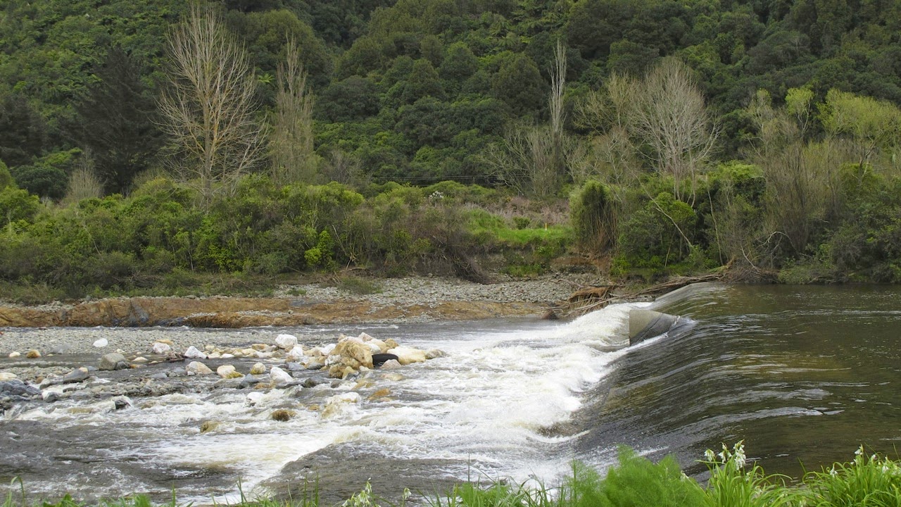
From a ride along here a year ago, I remembered the north bank track having to go through a stretch of private land where the track deteriorated to a narrow rut through grass, but we didn’t strike that this time. It must have been where the construction site for the new Expressway is now.

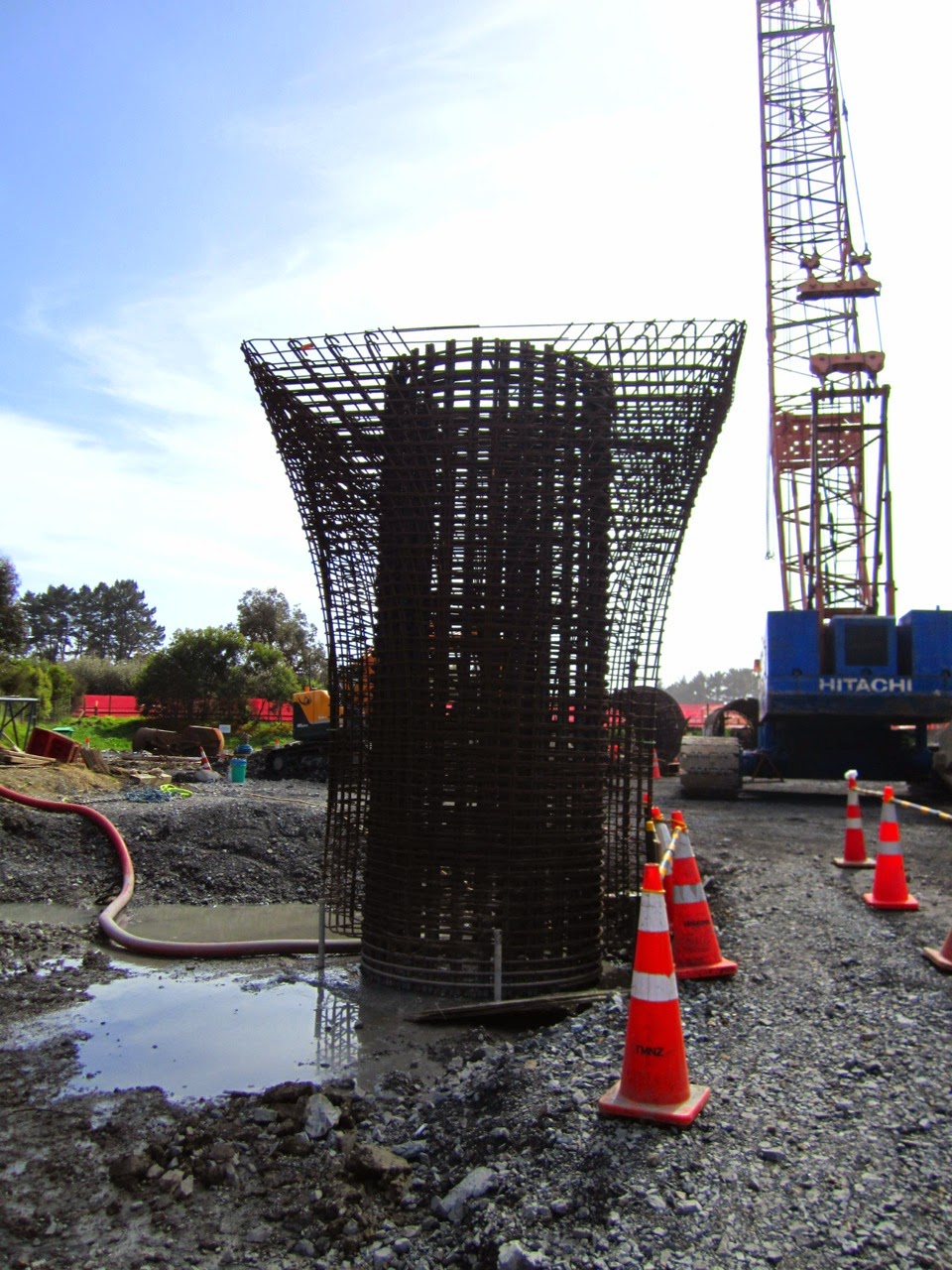
I took some photos through the fence surrounding the site. Some of the steel mesh reinforcing cylinders for the enormous pillars for the bridge were lying on their sides, and some had already been installed with their flared collars.

The reinforcing for the pillars to support the Expressway bridge

One of the installed pillars and its flared collar

At the estuary of the Waikanae River, the whitebait season appeared to be in full swing. At intervals along the edge were people minding their nets. I tried to take some photos of these idyllic scenes, but my camera misbehaved. I had three tries, and the ‘picture’ came out completely blank each time. I fiddled with the settings, then gave the camera to John to see if he could solve the mystery. He tried to take a photo and it worked fine! Aargh! that is so annoying, when something misfires for me, but then it works fine for him, without him actually having to change anything!

This is John’s photo of the whitebaiters. I reckon mine would have been better! (photo by John)

We stopped for coffee at the Long Beach Café on Tutere Street. We were amused at Daryl's way of discouraging any attempt to nick his bike: he simply took off the seat post and took it with him into the café.

Daryl's "security system" (photo by Alastair Smith)

After a leisurely coffee, we headed off towards Peka Peka. There was a strong nor’-westerly blowing, and it was a bit of a slog to ride into it. Before the Pharazyn Reserve (which used to be oxidation ponds but is now being restored to wetlands), we diverted off the road onto a short track that led through the sand dunes, with an option to end up at the beach. We kept on the track that ran more or less parallel with the road to Peka Peka. It was a bit more sheltered from the wind, but it did go up and down quite a bit.

The track through the sand dunes (photo by John)

Despite the headwind, it didn’t actually take us very long to get to Harrisons Garden Centre, where we had decided to have lunch. John B just had a cool drink, then left us as he was biking to Otaki, where he had to attend a meeting. He said he would have to ride on SH1 for a couple of short stretches. That would not appeal to me very much. I feel safe enough now to cycle on quiet roads, but a state highway, without much of a shoulder, would worry me.

Peka Peka Road, approaching Harrisons (photo by John)

Lunch passed very pleasantly with talk about bikes, electric bikes and places people had been cycling – both in NZ and overseas. Alastair has recently invested in an electric bike, which he wrote about on the Cycling in Wellington website, and since then John has been reading up about them, so there was a lot of information to be exchanged.

The ride back to Waikanae was great, with the wind now behind us. Alastair had thought we could perhaps ride on the hard-packed sand on the beach while the tide was out, but upon investigation, it turned out that the wind was whipping up the sand and making things unpleasant.

Anyway, as it was nearly 2pm, I reminded the guys that we didn’t have time to muck around if we wanted to catch the 2:30 train back to Wellington. So we pedalled along at a fast pace. Daryl rode ahead and we soon lost sight of him.

To save time, we rode along Te Moana Road, instead of along the river track, and the last 500 m – up an incline! – were a race against time. Alastair, John and I got to the station with only one minute to spare, and expected to see Daryl there, but he was nowhere to be seen. The train left without him. Alastair managed to get hold of him on the phone, and it turned out that he had taken the river track, and got to the station too late. He caught the 3pm train back and was still able to use his Gold Card.

On the train there was more bike talk between John and Alastair but I tuned out for a bit as I was feeling really tired. I did notice, while idly looking out the window, that there was quite a haze over the sea and that we could only barely see Kapiti Island.

It had been a nice ride (29 km), and enjoyable social time. We discussed where we could take the next Folding Goldies ride. Alastair suggested taking the train to Upper Hutt and riding the Akatarawa Road to Waikanae, and train back from there. John is keen, but I’m not so sure. It will involve a fair bit of climbing. “No more than one or two kilometres of uphill walking”, said Alastair. Yeah right! That’s 1.95 km too much to my way of thinking. But John suggested we go and drive the route sometime, to see how bad it really is. And check out Staglands for lunch, of course!


Friday 19 September 2014

Hutt Valley River Trail – Upper Hutt to Petone


Last Monday we made a snap decision to take a train ride to Upper Hutt and bike down the Hutt River Trail back to Petone. It was blowing quite a strong nor’-westerly wind, and this way we would have a tailwind for most of the way.

It was a matter of scrambling to get out of the house and down to Petone to catch the 1:17pm train. Even though it was not brilliantly fine, we thought we’d better get some biking in before the weather deteriorated again, as it is forecast to do for the next week or so.

We’ve ridden this track quite a few times now, in every season, but spring has to be the loveliest. Everywhere there was evidence of new growth. Kowhai and cherry trees in flower, the willows greening up, the yellow of flowering broom, and shrubby trees covered in little white flowers (hawthorn?). And then there was the pungent smell of onion weed and the fragrance of freshly mown grass.

The trees are greening up and the onion weed thrives beneath them (photo by John)
The track goes through a stand of beautiful mature trees close to the River Road Bridge
 (photo by John)

As we were getting close to the Silverstream twin bridges, there is an area where willow poles had been planted during the winter months – part of a flood protection scheme, I think. These poles are now starting to sprout at the top. Isn’t nature magical? There are big holes by the piles of soil and rocks, but I don’t know what they are for.

The willow poles are starting to sprout (photo by John)

A short distance further on, there is a weir across the river. I was surprised by the white rocks in the stream below it, as they somehow did not seem to “belong”, being quite different from any other rocks in the river. From a distance they looked as if they were coated in a whitish scum. There was also a nasty smell from the small sewerage pumping station nearby.

The white rocks surprised me, they don’t seem to “belong” (photo by John)

Where the track skirts the Eastern Hutt Road, it becomes a narrow gravelly path through a bushy area. But here the track was closed because of work being done somewhere up ahead. So we had to climb up another path that took us up to the road. It went past the top end of the waterlevel recorder from where we had a nice view over the river and the Manor Park golf course on the opposite bank.

The Daleks are coming! (photo by John)
Looking across at the Manor Park golf course (photo by John)

This is why we couldn’t use the path. I wonder what the drilling is for?
  (photo by John)

Further along, while riding on the stopbank above Taita Drive, we saw several crews resurfacing the road. The rest of the ride was uneventful. And we returned to our car in Petone, having biked 34 km.

Resurfacing Taita Drive (photo by John)

I love those greens! (photo by John)

Uneventful? Well no, not entirely ... When we got back to the car, we discovered that John’s camera was not on its handlebar bracket, as usual. Oh crumbs! Did it fall off somewhere along the way? Or perhaps John left it on the table at Janus Bakkerij when we stopped there for some coffee?

A phone call soon established that that was the case. Thank goodness there was still someone there to answer the phone. By now it was nearly 5pm, and the café was closed, but they were still cleaning up. Luckily we were able to drive back rather than having to bike back to collect the camera. Phew!


Tuesday 16 September 2014

Plimmerton to Pukerua


Last Monday, 8 September, we went for just a short ride from Plimmerton to the top of the hill at Pukerua. I had said to John I should try Te Ara Harakeke again, as in the past I’ve had serious misgivings about the steepness of the hill. His reply was “Yes, you want to see if your mountains have become molehills yet” (nothing rude intended!).

So we parked in Plimmerton, ducked under the station underpass, and rode up along the lovely walking/cycling path that skirts SH1. The beginning of it is quite easy, the gradient is very friendly, and with a slight tailwind, it was pleasant riding.

Te Ara Harakeke skirts SH1 (photo by John)

Just past Whenua Tapu Cemetery, the track starts to climb, and at first, it is not too daunting. It goes through a rather pretty area with shrubbery and cabbage trees. Then the serious climb starts.

I like the cabbage trees in this pretty area before the hill starts in earnest (photo by John)

I was so determined to bike all the way up, and not get off and walk. Oh, how my legs burned, and how my lungs gasped! I managed to bike almost to the top, but about two pedal strokes short of the top, I had to give in … I needed several minutes to get my breath back! But hey, I had just about done it, and there’s hope for me yet.

I must add that I couldn’t have done it if we’d had a headwind, but with a little push from the southerly, it was OK.

Once over the railway bridge, we rode a little distance into the side road at Pukerua, then turned around and rode back down the hill. Whee! It was great tootling down at speed, with the wind rushing past and making my eyes water.

We didn’t take many photos as it was such a short ride. The most interesting thing we saw was a convoy of huge trucks parked at the weigh station. They were all connected together – two in front and one at the rear – to pull and push a trailer with a very large, and obviously very heavy “thing” on it. We couldn’t work out what it was – perhaps a substation?

Two of the huge trucks at the front of the convoy (photo by John)

The “thing” that was to be transported, and the third truck, to push from behind (photo by John)

It was a short ride, just 12.5 km. And my “mountains” had not quite been reduced to molehills yet, maybe just “foot hills”?


Saturday 6 September 2014

Miramar


John thought we should explore the flat suburb of Miramar, so on Thursday 4 September, we parked the car near Greta Point and headed towards Evans Bay. It was a nice day, though there was a chilly south-easterly wind.

At the corner of Evans Bay Parade and Cobham Drive we looked at the sad remains of the Zephyrometer. This much loved kinetic sculpture by Phil Price consisted of a concrete cylinder holding a 26m tall needle which swayed to show wind direction and speed. On 14 August, Wellington experienced a sudden, brief but violent, hailstorm, accompanied by thunder and lightning. With dramatic accuracy, the needle of the Zephyrometer was hit by a bolt of lightning, and was effectively “fried” with a bang. This video shows the exact moment it was struck. (Note: it was hit only once, the video repeats the moment of impact a couple of times.)

The “fried” tip of the Zephyrometer after being struck by lightning (photo by John)

The damaged Zephyrometer has been tethered and surrounded by protective fencing

This website shows further photos of the damage that was done by the lightning strike (scroll to the bottom of the page). I do hope that the City Council will have this sculpture repaired. It would be really sad if they removed it. It was so indicative of Wellington as the “Windy City”, it should stay.

We rode on the walking/cycle path along Cobham Drive towards Miramar. As well as the official wind sculptures on this stretch, there are some impromptu artworks – or statements, or moments of fun. This one made us smile.

An impromptu artwork (photo by John)

At the entrance to Miramar, the big sign on the hill that usually says “Wellington” has been temporarily altered to read “Wowington” to celebrate the fact that “WOW” is about to take over the city in the next few weeks.

WOW or The ­World of Wearable Art is a fabulous show of the weird and wonderful ways creative people apply art to the human body. The show originated in Nelson, but was moved to Wellington ten years ago so as to reach larger audiences for its annual extravaganza (nearly 50,000 per season!). WOW's mission is to “take art off the wall and out of static display and to adorn the body in wildly wonderful ways. To celebrate this creativity in lavish and unique spectaculars which inspire all.” This year, there will be 14 shows between 25 September and 12 October.

The “Wellington” sign has temporarily become “Wowington” to celebrate “WOW” (photo by John)

Once past the cutting, we turned left into Tauhinu Road, and then up Miramar North Road, which climbs up the hill behind the California Garden Centre and Peter Jackson’s Park Road Post-Production Unit.

Pleasant but unexciting suburbia –- Miramar North Road (photo by John)

Coming down Weka Street, we ended up at “The Larder” for lunch. As we parked our bikes, we were greeted by a local cat. Having recently lost our cat Tim to old age and kidney failure, John immediately wanted to make friends with this beautiful fluffy feline. He has always been a cat person.

A friendly cat greeted us by The Larder Café (photo by John)

After lunch in the sun, we rode down Darlington Road, taking time to stop at a short lane off the main road, where John wanted to look at a house that he had lived in when he was a small boy. Of course, the place has changed over more than sixty years, with an extension and garage having been added.

As an amazing coincidence, we discovered that, a generation later, our son-in-law had also lived in that same house when he was small. And when we got to meet his family, we found that his mother and John had both attended Worser Bay Primary School and, in fact, had been classmates!

The house off Darlington Road where John lived as a small boy (photo by John)

We meandered around Miramar and towards Strathmore, past Scotts College. I thought that John was heading towards Calabar Road, where cars speed down from the airport towards Cobham Drive. I didn’t much fancy biking there, but luckily he knew of a pedestrian-and-cycle underpass that took us under the road and under the runway, and into Kilbirnie on the other side of the airport.

Maintenance being carried out in the underpass below the airport runway (photo by John)

In Kilbirnie we made a (compulsory!) stop at Burkes Cycles, John's favourite cycle shop, which was having a sale. We had a good old browse, but didn’t buy anything.

A stop at Burkes Cycles’ sale (photo by John)

From here it was an uneventful ride back to Evans Bay and Greta Point, with a couple of stops for pretty photos. We had biked 16 km.  

Yachts anchored off Evans Bay (photo by John)