Showing posts with label Wairarapa. Show all posts

Saturday, 9 December 2017

A Wairarapa weekend


On 4 and 5 November, we had a weekend in the Wairarapa. The trigger for it was that there was a Scottish Country dance in Carterton that we wanted to attend on the Saturday night. And we wanted to do some biking while we were in the area.

We booked a cottage in Greytown for our overnight stay, and arrived there after having had lunch in the village. It was just a street away from the entrance to the Woodside Trail. We knew we were going to bike this trail the next day with my sister and brother-in-law, who were spending the weekend elsewhere in the Wairarapa, but we thought we would check it out first.

The trail is very pretty – the trees were fully green, and the poplars at the start of the trail, which were mere sticks the first time we rode this track four years ago, when it had only just been opened, had grown quite large, and the planting on the bank on the right hand side had filled out to become lush mounds of grasses and flaxes.

The track in November 2017

The same track in August 2013
z
What a difference on the bank! (photo by John)

Although it was only five kilometres to Woodside station, it was nice having our electric assist, because we had a pretty strong headwind.

The grass is being whipped by the strong wind

When we got to the end of the trail we wanted to explore a bit further – looking for the loop that would take us to the river and back to town. But we ended up going past Woodside Station, and going down Waiohine Valley Road. It was gravel, quite corrugated to begin with, but it improved after a bit. We didn't think we’d want to take Aimée and Neil there, but we were keen to explore for a while.

Waiohine Valley Road

It is a beautiful valley, farmland and hills on the left, and glimpses of the river on the right. Lots of broom in flower which exuded a subtle fragrance.

Farmland on the left … (photo by John)

… and glimpses of the Waiohine River on the right

The flowering broom exuded a subtle fragrance

After quite a distance, we got to a place where the road looked like it was becoming private property. There was a gate, and though it was open and looked as if it hadn’t been closed in a long time, we didn’t go any further. When we turned around, we sidetracked for a bit to go to the river’s edge.

This is where we turned around (photo by John)

The Waiohine River (photo by John)

On the way back, we stopped at a paddock with three alpacas in it. When we went past on the way out, they all galloped away to the far end of the paddock. But on our return trip, one of them came rushing back over to the fence to check us out. He was very inquisitive, and made little noises in response to our talking to him. Very cute.

This gorgeous alpaca was quite inquisitive and “talkative” (photo by John)

We made our way back to the cottage, having biked 20 km. We had coffee on the little deck, and then we sat in the sun and read until it was time to head out for dinner, and then to Carterton for the dance.

Coffee on the deck of “Ivy’s Cottage” (photo by John) 

Scottish country dancing at Carterton SCD Club’s Annual Dance (photo by John)

The next day, we visited a Farmers’ Market in the grounds of the Te Kairanga Winery. It was in a lovely setting ­­– lots of stalls under the trees. We bought some fudge, some olive oil, some Leckerli (a chewy, spicy kind of biscuit from Switzerland that we used to love when we lived there as children) and had some yummy French crepes with sugar and lemon, which we ate on the steps in the sun.

At the Te Kairanga Farmers’ Market (photo by John)

The next thing on the plan was to drive out to Gladstone to look at the scarecrows. We had biked from Martinborough to Gladstone, along Longburn and Gladstone Roads on a couple of occasions last year, and while we were driving along this time, we were impressed with ourselves for having biked all that way! In fact, the distance we drove would now – almost! – put me off doing it again.

The Scarecrow Festival started nearly twenty years ago as a fundraiser for Gladstone School. During the first week of November, the whole district is said to get into the spirit of it, making scarecrows to display at the farm gates. However, this year there were fewer scarecrows along the road than in previous years, which was a little disappointing. But there were a good couple of dozen all along the fence at Gladstone School.

The scarecrows at Gladstone School (photo by John)

We took a few photos, but didn't hang about, as we had to get back to Greytown to meet up with Aimée and Neil for lunch at Saluté. We made it back at just the right time.

After lunch we drove to the Woodside trail to start our bike ride. It was very, very windy, and we set off into a fierce headwind. Unfortunately, we only made it to about half-way, as Aimee’s battery decided to pack a sad and died.

We had to turn around when Aimée’s battery died

We had to turn around, as it was near impossible to struggle against the wind without e-assist. A pity, because it really is such a lovely track, they would have enjoyed it. Of course coming back, the tailwind was quite nice.

After we had packed the bikes back into the cars, we sat on a seat and ate our Leckerli, and chatted. About 2:30-ish we headed home. It had been quite a nice weekend, despite the wind and the aborted bike ride.

Friday, 17 February 2017

Wairarapa


Since I made a careless statement in my last blog post about possibly riding the whole of the Rimutaka Rail Trail some time, John has been agitating for us to do just that. So the night before last, with a fine day forecast, we agreed to give it a go yesterday (15 February).

What we couldn’t agree on was the direction in which to do it. Part of the reason was the logistics of getting to the start and getting home at the end. The Wairarapa train line is a commuter service, allowing local residents to get into Wellington in the morning and home again at night. So there are very few choices.

One option was to take an early train from Petone to Maymorn, ride the Rimutaka trail, over the top, down the Wairarapa side, bike 12 km to Featherston, and take the late afternoon train back from there. This would mean an easy ride to the top, and a steep one down to Cross Creek. This was my preferred way.

The other option, which John preferred, was to take the early train to Featherston, bike to Cross Creek, ride the trail from the Wairarapa side, with the steep (but shorter) bit first, and then an easy ride back from the Summit, and take the train back from Upper Hutt. This had two advantages: the prevailing wind would be behind us; and we would end up in Upper Hutt, from where we could take a Hutt Valley train, which has services every half hour rather than just a couple at the end of the day. But I balked at the idea of having to do the steep bit, having to walk and push the bikes uphill at Siberia.

In the end we compromised, and scrapped the idea of using the train. We would go on a “recce” (reconnoitre) first. We’d drive to Featherston, and on to Cross Creek, bike up the steep start of the track from there, see how bad Siberia was, and go back. Then we would go to Greytown and ride the easy Woodside trail loop.

But it all panned out quite differently.

After coffee at Featherston’s Everest Café, we headed out towards Cross Creek on Western Lake Road. We noticed that there was a dedicated, unsealed (lime sand?) bike track alongside the road. It had to divert onto the road every time there was a one-lane bridge over a stream, and there were many. But at each bridge there was a warning to the cyclists to “give way to oncoming road traffic”. For the motorists, there were signs well ahead of each bridge, warning them to “Watch for cyclists”. But we didn’t see any cyclists at all.

It is just over 10 km to Cross Creek, but we overshot the turn-off. When we realised that we’d missed the turn-off, we decided to keep going down to the coast, to see what the other end of the Rimutaka Cycle Trail was like. 

It was a long way, 36 km from Cross Creek to Ocean Beach. But the road is good, and some of the scenery is very pretty. Part of it skirts along Lake Wairarapa, which actually does not look very inviting, as it is brown, and surrounded by flat land.

Eventually we got a view of the sea, the road changed to gravel, and we came to a sign saying “Grader working next 5 km”. Down a steep gravel road, Ocean Beach Road, all bumpy corrugations from the grader’s metal caterpillar tracks. Across a bridge – a short bit of sealed road – then onto more gravel road. The grader moved out of the way to let us and another car go past, and along to a rough stony area to park.

It is a beautiful, wild coast, and I just wanted to have a look, maybe go for a short walk, take some photos, then turn around and go back, but John was determined that we should bike some of the Ocean Beach Road. Aargh!

I just wanted to look and take photos, but John was determined to go for a ride

While we were getting the bikes ready, the grader went past and headed down the road. So we had to carefully pick our way on the freshly graded surface. The grader had stirred up the gravel, and left corrugated tracks and strips of gravel and soft sand that you had to negotiate getting across to get from one solid surface to another, if it became too stony. I must admit I didn’t much enjoy it.

The graded surface of the road was not nice to bike on (photo by John)

Luckily we didn’t go very far, as the road went through a stream. Not that it was deep or scary, but that sort of terrain is for young and fit people riding well-sprung bikes with big, fat wheels – not for the grey and clumsy on folding bikes with small wheels. And we preferred to keep our feet dry.

The grader had gone beyond the stream (photo by John)

We stopped short of the stream, and clambered up a narrow track that led to a wooden platform, that seemed to have no other purpose than as a lookout and place to take photos from.

We stopped short of the stream and left the bikes …

… and clambered up a short track

The view was certainly dramatic and expansive. Ahead was Palliser Bay, stretching from Cape Palliser on the left, to the Wainuiomata Coast on the right. Looking inland was the wide, shambling valley of a small stream – the Wharekauhau Stream – with some impressive looking cliffs. John remembers investigating the geology of these cliffs with a School of Earth Sciences student some years ago.

Looking towards Cape Palliser (photo by John)

The Rimutaka Cycle Trail follows this coast towards Wainuiomata (photo by John)

The Wharekauhau Stream has a wide riverbed, but not much water at this time of year
(photo by John)

As we were heading back, and I was crossing from one track into another, I skidded in a patch of soft sand. I could feel my front wheel slipping sideways out from under me, and I went sprawling! Full faceplant! When I managed to pick myself up, I was covered in grey dust, and had gravel embedded in my left knee and elbow, and in the heels of both my hands. I should have worn gloves!

I brushed myself down, after a fashion, and we continued on towards the bridge that we had crossed earlier, and took more photos. This river had more water in it, and also sported some interesting cliffs. On checking the map, we found this was the Wharepapa River.

Impressive cliffs and more water (photo by John)

On the bridge (photo by John)
The mouth of the Wharepapa Rver and view towards Palliser Bay

We came to a junction where the road changed its name. On the photo the sign pointing straight at me, said "To Wharekauhau". This is a very exclusive and expensive luxury retreat, where the likes of Prince William and other rich and famous people get to stay.

The sign to Wharekauhau is pointing straight at us

I thought I should have rocked up there and asked to use one of their bathrooms to clean myself up after my tumble. But that would have seriously lowered the tone of the place, wouldn’t it? So instead, we went back to the car, and I cleaned up my grazes as best I could with tissues and water from my drink bottle.

Clean-up time (photo by John)

Back on the road – in the car – back to Cross Creek. Despite my fall, we decided to check out the track at Cross Creek, since we were here. Somehow, the road back didn’t seem to take as long as it had on the way out. We stopped a few times for more photos.

Looking back towards Wharekauhau

The view down to Lake Onoke, and the bar that separates it from Palliser Bay
(click to enlarge) (photo by John)

We also stopped for a small herd of cattle – young steers, I think – being walked from one paddock to another.

Rural traffic jam (photo by John)

At the Cross Creek carpark, we talked to some people who had just come back from walking (the women) and cycling (the men) the Rimutaka Trail. They’d only gone a short distance, but they said it was very pretty, though quite narrow in places.

Well, we duly set off, and the very start was OK, but then the track became just a very narrow rut with grassy edges. I didn’t feel too comfortable about the drop to the right of us as we progressed, and I worried about John.

The track was narrow and became even narrower (photo by John)

I went ahead of John, and when I came to a spot where the track became very stony and looked like it had been, or was being, repaired, I waited for him to catch up. I wasn’t keen to continue. Having had one fall, I had no wish to take another spill, nor did I want to push my bike over rough ground.

John took a while to catch up – and he was walking! “Let’s call a stop to this”, he said. The narrowness of the track, and the drop to the right in some places were “messing with his balance”. Wearing his eyepatch, he has no peripheral vision to his right, so a drop on the right hand side of a narrow track is particularly scary.

The narrowness of the track was messing with John’s balance

So we returned to the car. He was disappointed, but I was relieved. It looks like we will not now be tackling the entire Rimutaka Rail Trail from either end. What a good thing that we had decided on a “recce” today, instead of trying to do the whole trail. Phew!

In the end, we decided not to ride the Woodside Trail out of Greytown, as originally planned, as we were both feeling a bit the worse for wear. So after a belated lunch in Greytown we headed on home.

So there we have it. We are able to cross two items off our “must-check-out” list: the Rimutaka Rail Trail on the Wairarapa side, and the Rimutaka Cycle Trail along the Wairarapa and Wainuiomata coast. Yay! I hope John has now got them out of his system too.

Thursday, 7 April 2016

Wairarapa again – Martinborough to Gladstone


The week before Easter, we went for a short ride from Mana to Pauatahanui and back (14 km). I was still not feeling quite right (abscessed tooth). But once started on antibiotics, I was starting to feel a bit better. During Easter, we went for two short rides – one on Sunday, 10 km on Te Ara Tawa, to see if the new section from Kenepuru to Porirua was open yet (it wasn’t); and the other on Monday, from Seaview to Janus Bakkerij and back (12 km).

By Wednesday 30 March, having finished my course of antibiotics, I was finally feeling like my old self again, and so we decided on a much longer effort, and repeat the ride we did a month ago in the Wairarapa – from Martinborough to Gladstone and back. At that time, we thought we should do the ride again some time, but return on the same, lovely and quiet, Longbush Road, instead of going on the much busier Ponatahi Road.

Quiet Longbush Road (photo by John)

Monday, 7 March 2016

Wairarapa ride – Martinborough to Gladstone


On Wednesday 2 March, having spent several days at my desk making changes to my blog, and not having biked for ten days, we thought we should do a substantial ride somewhere. And since there weren’t many rides listed in the Wairarapa Rides tab, we decided to remedy that by biking the route we had done when we took part in the Martinborough Charity Fun Ride, back in November. 

But instead of doing the 48 km loop without any stops in the middle, as there are no cafés along the way (how barbaric!), we decided to go as far as Gladstone so we could stop for lunch at the Gladstone Inn. This effectively meant we were doing the 67 km loop.

Wednesday, 4 November 2015

Martinborough Charity Fun Ride


Last weekend, on Sunday 1 November, we took part in the Martinborough Charity Fun Ride. I had heard about this yearly event from a friend, Karen, who had taken part in it last year, and was doing it again this year. 

I looked up the website, and thought it looked like an interesting challenge for us. I checked the regulations, and found that electric bikes were allowed. But seeing the photos of all these impressive looking cyclists in lycra, I had a few questions, so I fired off an email to the organiser, Graham Evans, asking him “is it only for seasoned cyclists in lycra and all the flash gear, or is it OK for a couple of reasonably fit seniors, in baggy trousers, on e-bikes to take part?”.

The answer came quickly: “The ride is definitely for anyone and you would be very welcome and I am sure you would enjoy it. And there are lots of riders not in lycra although we would love to sell you one of our mcfr jerseys”.

We hummed and ha’ed for a while. John thought that since it seemed to be a race (there were time rankings of previous years’ events on the website), it wasn’t really our style of biking. We like to take our time, enjoy our surroundings, take photos and stop for a coffee somewhere along the way.

Still, the idea niggled, and with a day to go, and an excellent weather forecast, we registered as late entrants for the 48 km ride. The other options were for 67 km or 115 km. We figured we would be quite capable of doing the 48 km option, as we have done that distance, and more, on other occasions, without difficulties.

Saturday, 16 November 2013

Wairarapa Weekend


We had a great couple of days in the Wairarapa last weekend (9 and 10 November). The trigger for going there was a dance organised by the Carterton Scottish Country Dance Club, entitled “Spring into Summer”, on the Saturday night. And spring into summer we sure did, as the weather was perfect. Summer is definitely on its way! But as well as dancing, we managed some cycling on both days – a total of 37 kms.

Before heading “over the hill”, we spent a couple of hours at the Highland Gathering in Harcourt Park, Upper Hutt. Here all sorts of Scottish activities were going on. Dancing competitions; piping and drumming competitions; about half a dozen “clan tents” displaying charts, tartans, books and paraphernalia to do with specific Scottish clans; a tug of war; a pipe band performance; a demonstration of Scottish Country dancing; even the opportunity to try shooting a "medieval" bow and arrow or a cross-bow (though I don’t know how that would be peculiarly Scottish). And of course, the usual coffee and food caravans, and a sausage sizzle.

On the stage, children and young people were competing in Highland and Irish dancing. They compete in their age groups and some of the girls are quite young. They look so cute in their formal kilt outfits, with matching socks, velvet vests and feather-topped hats. I’m sure these hats must have a special name, but I can’t find out anything about them.

Young Highland dancers’ competition

It is obvious that for the families of the children who compete, this is a whole way of life. Parents or support teams bring along their gazebos, folding chairs, picnic and all the costumes and trappings for the competitions. They settle themselves for the day at strategic points on the hillside facing the stage. It must be a great activity for families to be involved in.


Supporting families settle down to watch the competitions (photo by John)

Away from the main stage, under the trees, was the skirl of bagpipes and the sound of snare drums being practised, in preparation for facing the judges. You’d have to be good at ignoring all the other tunes being played while practising or performing your own piece. Impressive. The musicians perform individually in front of a judge, or in a pair consisting of a piper and a drummer. Interestingly, the competing tunes did not seem to clash or interfere with each other – not too much anyway.


Piping and drumming competitors

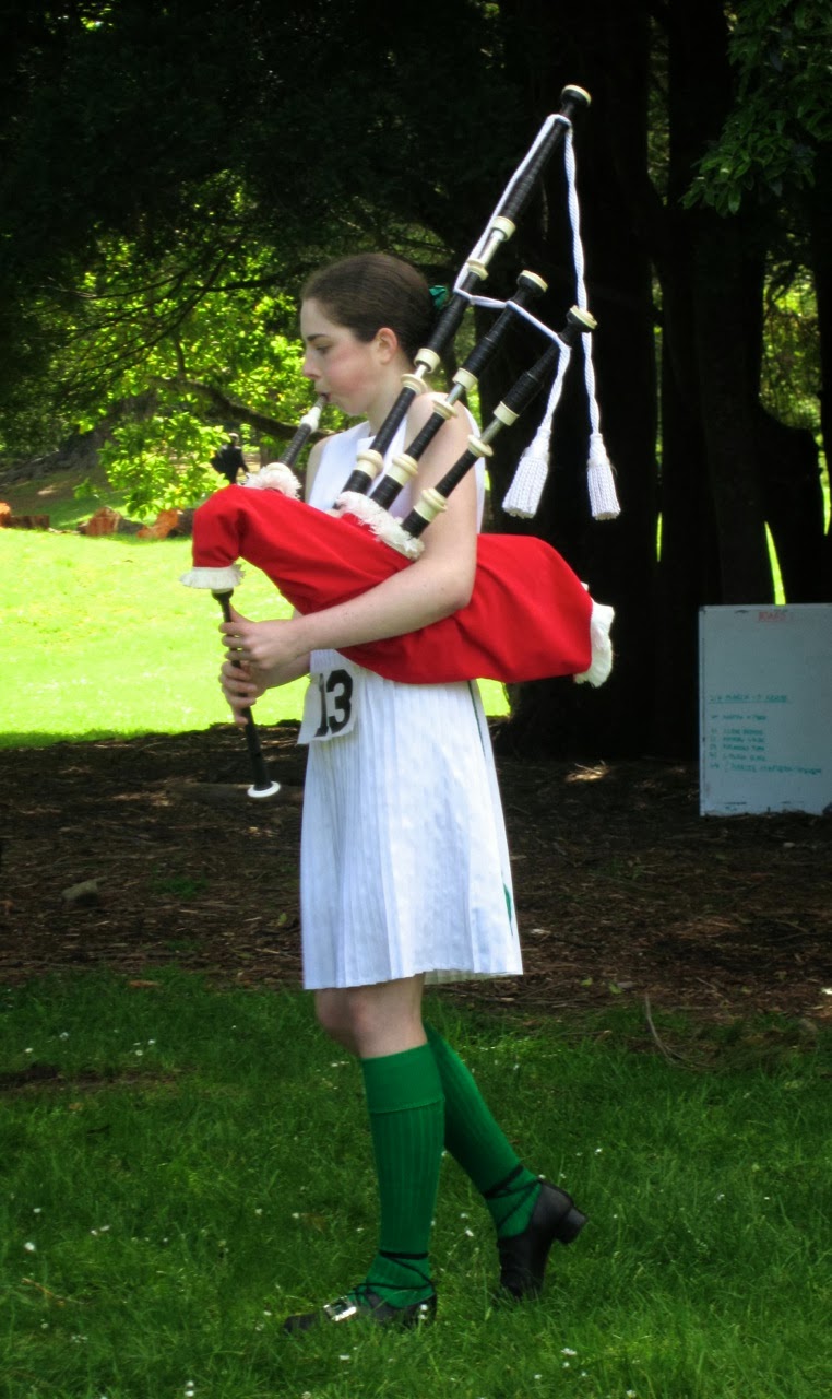
Some of the young people have multiple skills, competing in several categories. I watched one young woman in Irish dancing costume playing the bagpipes for a judge, having just been placed 2nd in Irish Dancing. Later I saw the same girl dancing in another Irish item, which required the most amazing stamina, calf muscle strength, and memory. And later again, I saw her performing a Highland dance, having changed her costume to a kilt and velvet jacket.


A gifted, multi-talented young woman plays the bagpipes before a judge

At midday, competitions stopped for the lunch break. To entertain the crowds, there was a performance by the Kapiti Coast Pipes and Drums Band. They marched onto the lawn in front of the stage, and formed a circle to play number of stirring tunes. I noticed that only the pipers had feathers in their caps, the drummers just had little red pompoms on top. I wonder why? I also noticed that the drummers had to wear their sporrans pushed to the back, because they would otherwise get in the way of their drums.


The Kapiti Coast Pipes and Drums (photo by John)


The drummers are twirling their drumsticks aloft

After the band had marched off into the distance, it was the turn of six members of the Upper Hutt Scottish Country Dance Club to demonstrate some dances. They performed four dances, on the grass. In between dances the leader (and teacher of the club) spoke about the dances, and about SCD in general, inviting anyone who would be interested in finding out more, to join them for their classes on Wednesday nights.


Members of the Upper Hutt SCD club dance a strathspey called “The Minister on the Loch”

We stayed to watch a little bit of the tug of war, then headed off, over the hill to Greytown and some lunch.


The tug of war (photo by John)

After lunch we cycled the Greytown to Woodside Rail Trail. Parts of the trail looked quite different from when we rode here in August. Back then, being winter, all the trees were bare, but now they were all wonderfully green. The young trees near the beginning of the trail, which in August were mere sticks, and which I thought were cherry trees, turned out in fact to be poplars, and they had grown considerably in the past few months.


The beautiful oak trees were in full leaf


I like this view of the path skirting the paddocks (photo by John)

It didn’t take us very long to get to the Woodside Station. This time, instead of going up to the new station, we took the track on the other side of the railway line, towards the old derelict station. When the new station was built, the old one was used as a storage shed for some years. But now it's been abandoned to the elements.


Vegetation tries to overwhelm the derelict old station building (photo by John)

Inside the old building, nature has tried to take over, with grass growing in gaps in the concrete floor, and the aerial roots of the creeper that is growing up to and into the roof, hanging from the rafters.


Inside the old building, grass grows in the gaps in the concrete (photo by John)


Aerial roots of a creeper hang from the rafters (photo by John)

The old and the new stations – basically the same design

On the way back I spotted some alpacas (or are they llamas?) in a paddock near a house. I had to peer through the trees to be able to take a picture of them.


Alpacas – or are they llamas?

These trees don’t look anything like “whomping trees” anymore now that they are in full leaf (refer to my Greytown post of 18 August) (photo by John)

It was a nice short ride, only 10kms, done in less than an hour, but just enough to keep us occupied before we checked into the motel we had booked in Carterton. The motel wasn’t anything to write home about – plain, very 1970s décor, fake Spanish hacienda. But it was clean, and the host was very pleasant.

It was still sunny so we found a place to sit by the motel’s pool. The area had obviously not yet been prepared for summer, as the water in the pool was a murky green and there was all sorts of debris floating on the top. But no matter, there were some chairs there and we sat in the sun with our orange juice, chippies and books for a while.

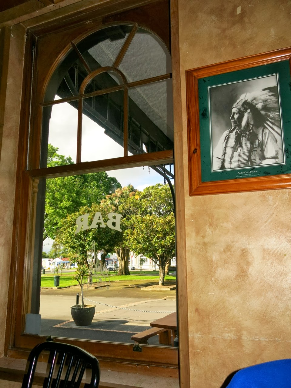
Before heading to the dance, we had dinner at the Carterton pub, Buckhorn Bar and Grill, where we had a very generously sized and reasonably priced meal. The interior of the pub had a Wild West theme, with photos of Indians and cowboys, posters of rifles and handguns of the era, and photos of Western movie stars.


Inside the “Buckhorn Bar and Grill” (photo by John)

Carterton’s Memorial Square in the late afternoon sun (photo by John)

The dance was very well attended, with more than 50 people there, many of them visitors from Wellington, Hawke’s Bay, Rangitikei and even Wanganui.


The dance was well attended and everyone had a great time (photo by John)


On Sunday morning we parked the car in a side street and rode all around the side and back streets of Greytown. It is such a pretty township with lovely houses and gardens in tree-lined streets.
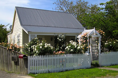

A delightful rose-covered cottage

Beautiful tree-lined streets (photo by John)

Riding on the roads was not a problem, as there was virtually no traffic, and it was all on the flat. I would think that for people like me, who don't like to risk having to compete with fast-moving traffic, the back streets of many NZ country towns would be a good alternative to dedicated cycling trails. And it is a good way to get to know a town, too.


Another gorgeous street (photo by John)

The township is not very large, and soon we were riding around the rural perimeter of the town. Here the new houses were set well back from the roadside, on rather large sections. If you were wanting a semi-rural lifestyle, this would be ideal – provided you had the funds, of course.

Along this road on the edge of town, large modern houses on huge sections are hidden from view behind the trees (photo by John)

At the end of Udy Street, we came to a gate and a sign saying Walkway/ Cycleway/ Nature Trail. So of course we wanted to try it out. But first we said hello to a horse by the fence. While we were doing so, I was amused to see a rooster come rushing over to us. He must have been thinking that if the horse was going to be given something nice to eat, he wanted some too! He was in such a hurry, he kept tripping himself up in the long grass! Quite comical.


A beautiful rooster rushed over to see if we had anything to offer

The cycleway really wasn’t very good to ride on. It was very rough and bumpy, and in places the gravel was deep and skiddy. It didn’t go very far though, because we soon got to the Waiohine River. I believe there are plans – long-term plans, perhaps – to join up this track with the Woodside trail to create a full loop. That would make a really lovely ride, especially if it would run beside the river some of the way.


Cycleway leading to the Waiohine River

The Waiohine River (photo by John)

The way back into the town led down some lovely lanes. Through a gap in a hedge, I spotted some sheep resting in the shade of some trees. I thought that would make a lovely peaceful picture, but as I pulled up and carefully approached the fence, one lot looked at me in alarm and got up, ready to run. Silly things. Fortunately, the ones under another tree, a bit further away stayed put, so I did get my peaceful, bucolic photo.


Sheep resting in the shade of a tree

I love the regularity of these trees and fence posts

We cycled pretty much all of the back streets on both sides of the main road, and clocked up 22 kms. We were intrigued by signs pointing this way or that, saying “Rug Sale”. The signs were everywhere, but we never actually came across the place where the rug sale was.

By about 1:30 pm, we thought it was time to stop for lunch, so we headed towards Martinborough to look for a winery with a café. We found what we wanted at the Margrain Vineyard Café. A lovely setting with tables scattered on the lawn overlooking the vines. We chose a table in the semi-shade of some large trees, as it was getting quite warm in the sun.


Lunch at the Margrain Vineyard Café (photo by John)

The vines

Lunch was very satisfying, and the glass of Riesling was so delicious that we stopped at the winery shop afterwards to buy a couple of bottles to take home.

After a leisurely lunch and yummy dessert, we went for a bike ride around the vines, circumnavigating Martinborough and finally through the square. We rode about five kilometres, which was enough, because by now a brisk breeze had sprung up and made the going a little harder.

Finally we walked around the Martinborough town centre, browsing the shops. Parked outside one of the shops was a magnificent motorbike, which had several admiring males around it – practically salivating … Of course John had to take a picture of it. It was a beautiful looking machine, I must say, but I’m happy with my bike, thank you.

This beautiful motorcycle stopped several men in their tracks (photo by John)