Tuesday 22 December 2015

South Island Lupin Trip – Part 3


In late November we travelled to the South Island, in search of the flowering lupins. We were delighted to find that we had come at exactly the right time, for the lupins were magnificent and they were everywhere!

We were away for 12 days, and took more than a thousand photos between us, so I have had to write up this trip in several parts (No, you won't have to plough through all thousand!). This is where you can find Part 1 and Part 2.

Day 6 – Pukaki Canal and Glen Lyon Road


Tuesday 1 December. On our Pure Trails tour last summer we biked along the Pukaki Canal on our way to the Ohau Lodge. Today, our plan was to bike down the Glen Lyon Road (along the Pukaki Canal), and then continue on this road, up the right hand side of Lake Ohau, along the base of Ben Ohau, the big hill/mountain that dominates the lake. To return, we would go back to Twizel on the road on the other side of the canal.

We biked out of town along the Glen Lyon Road (photo by John)

Monday 21 December 2015

South Island Lupin Trip – Part 2


Prompted by the sight of profusely flowering lupins, when we cycled in Waikanae the previous week, we made a snap decision to travel to the South Island to see the Mackenzie Country lupins in flower – a long-held wish of mine.

We were away for 12 days, from 25 November to 7 December, and took over a thousand photos between us, so I have to write up my blog in several parts. Part 1 can be found here


Day 4 – Lake Pukaki and Mount Cook


Sunday 29 November. We woke to a beautiful day, calm, with just a light but cool breeze. We took one last photo of the view over Lake Tekapo from outside our accommodation. What a view!

A last look at Lake Tekapo (photo by John)

Friday 18 December 2015

South Island Lupin Trip – Part 1


In my last blog, I mentioned that we had made a snap decision to go to the South Island to see the flowering lupins in the Mackenzie Country. Well, we went at exactly the right time, for we saw thousands upon thousands of lupins in the most glorious colours! What a feast for the eyes.

Thousands of lupins – these were beside the Lindis Pass road (photo by John)

Of course we took the bikes, and we had another brilliant cycling holiday. Hooray for being retired, and being able to just drop everything and take off like this. We count ourselves very lucky…

Tuesday 24 November 2015

Waikanae


Thursday 19 November felt like summer had arrived – well, nearly. It was a gorgeous day, but still a little cool. We drove to Waikanae, where we parked – as usual – in the Otaihanga Domain.

We biked around the Waimanu Lagoon, where a class of children was being taught to sail little yachts (sorry, I don’t know the correct name for this size of craft). Conditions were perfect, with just a little breeze.

Half a dozen children at a time are learning to sail (photo by John)

Monday 23 November 2015

Porirua to Pukerua


Last Monday, 16 November, we went for a ride from Porirua to Pukerua and around about. We parked in Parumoana Street, and got onto the walking/cycle path that would take us across the motorway and towards Aotea. But first the track went underneath the motorway on-ramp, and there we struck a hitch. The tide was in, and the Porirua Stream was running high enough to cover the lowest part of the path. We weren’t sure how deep the water was, so we made a u-turn, and backtracked a bit so that we could cross the road above. When we returned later in the afternoon, the water had receded, but there was a drowned rabbit where the water had been. Good thing we didn’t try to ford the water earlier.

The Porirua Stream is tidal, and the tide was in (photo by John)

Wednesday 11 November 2015

Folding Goldies ride – Whiteman’s Valley


On Friday 6 November we went on another Folding Goldies ride. Originally the ride was to have taken place on the Wednesday, but the forecast for that day was so horrible – rain and gale force southerlies – that we decided to postpone until Friday. It was a good call.

Wednesday was truly dreadful. I felt sorry for Prince Charles and Camilla, who arrived in Wellington, in a howling southerly gale and freezing driving rain, for a week-long official visit to New Zealand. Poor Camilla, who apparently fears flying, having to land in a Wellington gale! Anyone who has ever flown into Wellington on a windy day knows what a bumpy landing that can be. And not only that, but hardly anybody was interested in their visit, as NZ was still much more preoccupied with the return of the All Blacks from their exciting Rugby World Cup win. They were being feted in a victory parade in Auckland, and most of Wellington’s general public would have been glued to their TV sets watching the All Blacks and not the royals.

By contrast, Friday was a beautiful day – sunny, mild and just a very light breeze. Perfect for a bike ride. The plan was to take the train up to Wallaceville (just before Upper Hutt) and from there, ride up Wallaceville Road into Whiteman’s Valley.

Wednesday 4 November 2015

Martinborough Charity Fun Ride


Last weekend, on Sunday 1 November, we took part in the Martinborough Charity Fun Ride. I had heard about this yearly event from a friend, Karen, who had taken part in it last year, and was doing it again this year. 

I looked up the website, and thought it looked like an interesting challenge for us. I checked the regulations, and found that electric bikes were allowed. But seeing the photos of all these impressive looking cyclists in lycra, I had a few questions, so I fired off an email to the organiser, Graham Evans, asking him “is it only for seasoned cyclists in lycra and all the flash gear, or is it OK for a couple of reasonably fit seniors, in baggy trousers, on e-bikes to take part?”.

The answer came quickly: “The ride is definitely for anyone and you would be very welcome and I am sure you would enjoy it. And there are lots of riders not in lycra although we would love to sell you one of our mcfr jerseys”.

We hummed and ha’ed for a while. John thought that since it seemed to be a race (there were time rankings of previous years’ events on the website), it wasn’t really our style of biking. We like to take our time, enjoy our surroundings, take photos and stop for a coffee somewhere along the way.

Still, the idea niggled, and with a day to go, and an excellent weather forecast, we registered as late entrants for the 48 km ride. The other options were for 67 km or 115 km. We figured we would be quite capable of doing the 48 km option, as we have done that distance, and more, on other occasions, without difficulties.

Tuesday 3 November 2015

Tawa to Plimmerton


On a fine Saturday last week (24 October), we biked from Tawa to Plimmerton and back. We again parked at Takapu Road railway station. John suggested we could bike from home, but I am still a bit worried about biking on Middleton Road (see postscript below), which has either a very narrow shoulder or none at all, and there is a reasonable amount of car traffic using that road with the speed limit being 70 km/hr on the most winding part!

We biked the same route as we had a couple of weeks earlier, taking time to linger near the Mana Marina area for a bit. We discovered that recently, a garden area near the yacht jetties had been “embellished” by the display of a number of colourful garden gnomes – one of them, gruesomely, lying face down with a knife in his back!

Miscellaneous rides


Here I am. I need to do some catching up.

We did a couple of rides without taking any photos. One was a local “errands ride”, to the Resene shop in Johnsonville, then to our local café in Middleton Road, and home via the supermarket. Not very exciting, but good to be able to do these things without using the car.

Tawa to Mana


On Sunday 11 October, we started out from Takapu Road station. Being a weekend, there was plenty of parking there. We biked on Te Ara Tawa, beside the railway line and through Linden to Porirua. The only photo we took was of a little waterfall in the Porirua Stream, where a shag (cormorant) was sunning itself on a rock.You'll need to click on the photo to enlarge it if you want to see the shag ...

Porirua Stream near the Linden sportsground (photo by John)

We carried on towards Aotea, past the Aotea Lagoon and the Police College. Across the footbridge at the Paremata railway station, and on towards Mana, where we stopped for lunch at Café Ruby. It was a sunny afternoon and the café was busy, so we were there for quite a while.

Back the way we came, and at the new subdivision of Aotea, we decided to explore the new streets for a bit. We are looking to have our house re-roofed and painted, so we were interested to see the various treatments and colour schemes in the new houses. We also stopped and looked into a couple of the half dozen show homes that were open for viewing. Very nice!

We did about 32 km on this ride.

                                                  * * * * * * * * * * * *

Miramar Peninsula


On Tuesday 20 October, a lovely calm day, we decided to do another ride to the Ataturk Memorial, high up on the Miramar Peninsula. We parked the car at Greta Point, and biked around Evans Bay and Cobham Drive to Miramar, from where we headed uphill. Last time we got ourselves a bit confused and had trouble finding Bowes Crescent from where we could get access to the Ataturk Memorial. No such problems today.

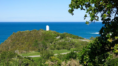
The memorial reserve sits on a steep promontory above Tarakena Bay, looking out to Cook Strait. On a bright sunny day like this, its white cylinder stands out sharply against the blue sea.

The Ataturk Memorial looks out over Cook Strait (photo by John)

At the memorial (photo by John)

The last time we were up here, there was a terrific southerly swell, and the waves created a chevron of foam as they rolled in from both sides onto the rocks off the headland. This time, however, the view was peaceful and we revelled in the beautiful colours of the water.

The seas around the rocks were beautifully calm (photo by John)

After an interesting chat with a couple from Auckland, we biked down the wide track to Moa Point Road, and rode around the peninsula to Breaker Bay. We stopped at the carpark near the beach for a closer look at the rocks. In the distance we could see Steeple Rock, which is near where the Interisland ferry Wahine sank in 1968.

The rocks at Breaker Bay, with Steeple Rock in the top one-third of the photo (photo by John)

Looking across the harbour entrance to the Pencarrow Lighthouse.
You can see Barrett Reef – the cause of the sinking of the Wahine (photo by John)

After the Pass of Branda – which sounds worse than it is – we rode through the suburb of Seatoun, round Worser Bay, and to Scorching Bay, where we had lunch at the Scorch-O-Rama Café.

A pleasant ride around the rest of the peninsula took us back to our car. We had done 26 km.


Sunday 1 November 2015

Ohariu – Makara – Karori


Oh dear, I haven’t written up any of the rides we have done over the last month! Must get on with it.

On Wednesday 30 September, the day after our Petone to Eastbourne ride, it was still fine, and the forecast for the next few days was not very nice, so we had to make the most of it. We decided on Ohariu Valley, to Makara, and back through Karori. It was lovely, and quiet, only a couple of cars went past.

In the Takarau Gorge we were amazed at the grassy debris hanging in the fence between the road and the stream below. It looked like the stream must have risen to well above road level in the last lot of heavy rains.

Flood debris from the stream below hangs in the fences (photo by John)

When we got to the Makara turn-off, we tried to go up to the West Wind Recreation Park (where the windmills are). There was a sign at the bottom of the road saying the park was closed due to lambing, and would be opened again on 1 October. Well, it was 30 September today, only one day to go! Surely that would not be such a big deal? Stickler John thought we should not go up. But pragmatic me, I reckoned one day would not make any difference. So up the VERY steep road we went. However, we came to a locked gate, with the same message. Aww, darn, too bad!

Taking a breather on the very steep road up to the West Wind Recreation Park (photo by John)

Closed for lambing!

The way back down was great! (photo by John)

So we pedalled on towards Makara Beach, which was deserted. We couldn’t even get an ice cream at the shop/café, as it was closed. Along the way, John spotted a trio of men sitting in camping chairs by the stream. I guess they were probably whitebaiting, but maybe they were just having a companionable chinwag in the sun, away from “her indoors”.

Enjoying the sunshine (photo by John)

Makara Beach (photo by John)

So on towards Makara village and the hill back to Karori. Just at the edge of the beach settlement, I noticed a fence that had been decorated with masses of paua shells. The letterbox in the shape of a cottage completed the rustic effect. 

A paua fence

We made a brief “chocolate” stop at the cemetery by the little church, then tackled the hill. It is quite a climb, and I was looking forward to the descent into Karori. But when we were nearly at the top, John decided to investigate the Skyline Walkway. The sign said “Access to Karori Park”. That’s where we were planning to have lunch, wasn’t it, so why don’t we go down here?

I had reservations about the track. Is it suitable for bikes? John’s comment, “You won't know till you try it”. It started out OK, wide and not too steep.

The beginning of the track looked OK … (photo by John)

We asked a couple of women who were coming up the path, and they said it would be OK. Stupid women! It wasn’t OK, far from it! It was terrible! Very soon it became very narrow, and steep, and rough - lots of tree roots, rocks and hollows.

… then it started to deteriorate

We had to walk and manhandle the bikes over roots, rocks and hollows! (photo by John)

And some of the time we had to push the bikes uphill!

We had to walk the bikes, which was hard to do as they were heavy to hold back, when they wanted to roll down the steep slope. Unbelievably, we met a mountain biker - young, bearded and fit, and patently, bonkers! - who was BIKING UP the track! He waited patiently in a wider bit of the track to let us stumble past, before haring up the hill again. We asked how much further it was to the bottom, and he said this was about half-way. Oh, cripes! We struggled on, and eventually made it down to the park, and the café. Phew! We won't be doing that track again!

After lunch at the busy café - lots of mothers with kids, as it was the school holidays - we biked through the backroads of Karori, through Wilton and on to Crofton Downs. There we took the train back to Johnsonville, as I didn't want to bike through Ngaio and Khandallah, or struggle up any more hills. By the time we got home (we biked from Johnsonville, of course) we had done 39 km - quite enough for one day, especially since we had done 33 km the day before!

Friday 16 October 2015

Petone to Eastbourne


On Tuesday 29 September, we decided on an easy ride from Petone to Eastbourne. Although the ride was all on the flat, we took the electric bikes, as there was a brisk breeze.

We parked at the motorway end of Petone and biked to Days Bay without stopping. There is a bit of a cycle lane on the seaward side of the road in most places, but at times we had to cross and ride on the road. We stopped for coffee and a scone at the Chocolate Dayz Café.

Fortified by coffee at Chocolate Dayz (photo by John)

It was a pleasant ride round the bays to Eastbourne. It seemed to us – but we may be mistaken – that the shape of the beach had changed since were last there. It seemed more ‘scalloped’ somehow.

We thought the beach had changed shape (photo by John) 
The same stretch of beach, seen from the other end (photo by John)

We biked to the end of the road, stopping at Burdan’s Gate, the starting point to the Pencarrow Lighthouse track. We did not want to bike there today – in any case, the silly gate which gives pedestrians and cyclists access to the track is too awkward to manoeuvre the e-bikes through. And these bikes are too heavy to lift over the main gate across the road.

Coming back through Eastbourne, we took a little detour onto the wharf.

The Eastbourne wharf (photo by John)

As we were riding along the riverside track at Seaview, we saw, up ahead, the little yellow tug Kowhai pushing along the dredging barge with a digger on the top. John raced along to catch up with it so he could take a photo.

The tug Kowhai, and the dredging barge (photo by John)

On the Waione Bridge across the Hutt River, there are always people fishing, causing a bit of an obstruction on the narrow foot/cycle path. Sometimes they have a bike or paraphernalia near them on the footpath, so you have to dismount to get past. This time, when we rode past one of the anglers, something wet and slimy hit me on the side of the face. I don’t know what it was, it didn’t hurt but it was pretty icky! At least it didn’t smell!

The rest of the way back to the car was uneventful. We had done 33 km – a reasonably respectable ride.

Cherry Blossoms in Whitby


Wow, it seems like such a long time since I last wrote up a blog post. We have been cycling, but I’ve had no time to write things up.

On Thursday 24 Sep, we went on a Folding Goldies ride. As pre-planned dates tend to go, you have no control over what the weather will be like on the day, and this time, again, it was not a particularly brilliant day – quite cold and wet.

The date was determined by the flowering of the cherry trees in the Japanese garden in Whitby. The walking/cycling path runs through it, and on previous rides we had speculated on how lovely they would look at the right time of year. The plan was to take the train to Porirua, bike through Bothamley Park to Whitby. Then on to Pauatahanui for lunch, and back to Mana for the train back. There were six of us – a few more than usual – and for the first time, another woman came along.

As expected, the track through Bothamley Park was quite wet. The wide path through the forest was was OK when on the gravel, but some part were quite muddy.

The lower end of Bothamley Park (photo by John)

Fortunately the muddy track had a solid base (photo by John)

We emerged from the forest track, and crossed the road (don’t know which road it was!). Here several of the group stopped to take off their parkas, as it was warming up a bit and the rain had stopped. I am glad that I didn’t take mine off, because on the next track, I went for a spill in the mud.

Time for some of us to shed a layer (photo by John)

We avoided riding on a very soggy bit of track, and diverted along the edge of a sports ground, where the “track” was basically a concrete draining channel. I tried to avoid a broken bit of concrete, and strayed onto the soft edge of the grass, promptly losing traction and going for a skid. Result: I came a cropper, landing on my left side in the mud. Because it was soft and wet, I did not hurt myself, but I did get filthy dirty. Lucky I was wearing my parka over my nice new blue Tineli jacket (which is not so easy to wash!). The parka was easy to sponge clean when I got home.

The walking/cycling paths in Whitby are very nice indeed. We duly reached the Japanese Garden with all its lovely Sakura cherry trees in bloom. This garden celebrates Porirua’s sister city of Nishio, in Japan.

Despite the gloomy sky, the frothy look of the cherry blossoms was a treat, especially as there were still some daffodils out under the trees. Apparently it is tricky to find a time when both the blossoms and the daffodils (which tend to flower a bit earlier) are both at their best. I reckon we were lucky to see both.

Stopping to take photos (photo by John)

Cherry blossoms and daffodils

As we were lingering near the cherry trees, taking photos, a local walking group came along with the same purpose. They told us that usually their group was much larger, but the rainy weather had put some of them off.

Cyclists meet walkers (photo by John)

We stopped for a leisurely lunch at the Ground Up Café in Pauatahanui, and then rode back to Mana via the Camborne Walkway. The weather had sort of cleared by then, and John would have been quite happy to ride all the way back to Porirua or Takapu Road (where we had parked the car), but I felt that 20 km was enough, especially since we were dancing in the evening as well. The others decided that they would take the train back from Mana, so we did too.

For the next Folding Goldies ride, it has been decided that we will ride the Whiteman’s Valley Road.

Thursday 1 October 2015

Two short rides – Hutt River Trail and Wellington Waterfont


It’s over three weeks since the last bike ride I wrote up. Hmm, this sounds almost like a confession. In that time, we’ve done two rides – 16 and 10 km – on the Giants (i.e. the non-electric bikes), and three rather more substantial rides on the e-bikes.

On Sunday 13 September, we went into Petone to have a look at the Home Ideas Centre (as we are looking to get some work done on our house), and just on the off-chance, we put the bikes in the car too.

After our visit in Petone, we drove to Lower Hutt’s riverside car park, and biked up the valley. It was sunny and calm, but a southerly was expected later in the day.

I was giving my new cycling jacket its first outing. I had a great deal of trouble finding one that fitted, but finally the lovely Jenny at Scott’s Outlet in Petone came up trumps for me. The thermal softshell fabric is beautifully warm and really keeps the wind out, but I miss the convenient pockets of my other blue jacket. Never mind – one can’t have everything perfect …

First outing of my new Tineli cycling jacket (photo by John) 

We rode up the eastern bank of the Hutt River, had lunch at our “usual” café, Janus Bakkerij, and continued until some distance beyond the Kennedy Good Bridge. We were happily pedaling along, when John suggested it would be wise to turn around now, as the southerly was about to hit. How did he know? “The going is too easy, we must be getting a tailwind”, he said.

He was right. We turned around and went back to the bridge, where we crossed to the western bank. We now had a southerly headwind, which grew steadily stronger. With our non-e bikes, pedaling into it was quite a bit harder than we've become used to lately on the e-bikes. A good reminder, actually. It is too easy to become complacent.

This part of the river bank has been repaired after suffering severe scouring in the May floods
 (photo by John)

Heading south on the western bank of the river (photo by John)

We crossed back to the other side over the railway bridge – there is a “tacked on” foot/cycle path – to get back to the car. We had done 16 km.

                                                     * * * * * * * * * * * *

The next day, it was still fine (a bonus, as spring has taken such a long time to establish itself), so we went for an easy ride along the Wellington waterfront. We rode 10 km from the far end of Oriental Parade to the Stadium and back. It’s a ride we do often, so there’s nothing much new to say about the ride, but John took some interesting photos, which I’ll share here.

Logs on the wharf, seen through the etched glass of the canopy over the footpath near the Stadium
(photo by John)

Ferg's colourful kayaks on Queen’s Wharf (photo by John)

Textures on the centre wall of the bridge over the Frank Kitts Lagoon (photo by John)

A forest of posts on Taranaki Street Wharf, with the floating crane Hikitea in the background
 (photo by John)

Reflections by the Clyde Quay Wharf Apartments (photo by John)


Tuesday 15 September 2015

Waikanae


On Tuesday last week, conditions were finally right for a long bike ride. The weather was good and we had overcome our lurgies (John) and concussion (me). We went to the Kapiti Coast, as it looked like the weather might be just a bit better there. And so it was – spring’s here!

At the Otaihanga Domain, where we parked, we watched as a family of ducks waddled towards a large puddle to take the babies for a swim. Mum, Dad, eleven ducklings, and a few aunties too.

No fewer than eleven ducklings! (photo by John)

Ah, a lovely puddle for a safe swim … (photo by John)

While biking through the Waimanu Lagoon Reserve, we spotted another young family – a pair of black swans and six fluffy, grey cygnets. They must be well used to human admirers, as they swam towards us solicitously when we stopped to take photos. When they found we didn’t have any offerings, they paddled off again.

They came to investigate us … (photo by John)

… and then paddled off again (photo by John)

We headed down through Waikanae Beach, and onto Rutherford Drive towards Peka Peka. There is a little path that detours off the road, and meanders through the sand dunes. Several of the hill sides around a lagoon area have recently been planted.

New planting in the sand dunes (photo by John)

Reflections on a lagoon (photo by John)

We pushed on towards Peka Peka for lunch at Harrison’s, followed by a wander around the adjoining garden centre.

After returning to Waikanae, we followed the river track as far as the Te Arawai foot bridge, where we crossed and headed back along the opposite bank. Evidence of spring finally arriving was all around – fresh tender green on the willows, daffodils in the paddocks, a lamb or two, and the smells of flowering wattles, onion weed and freshly mown grass. When we got back to our car at the Otaihanga Domain, we had biked 31 km.

Since it was such a glorious day, we took the long way home by driving up the Paekakariki Hill Road. The fabulous view from the lookout makes for a compulsory stop. There was very little wind – just enough for an updraft, which was made good use of by a paraglider, swooping down to the beach and then back up overhead and down again.

The view from the Paekakariki Hill lookout towards Paraparaumu and Kapiti Island
(photo by John)

The glare off a calm Tasman Sea (photo by John)

The paraglider swooped over the top of us and away again