Prompted by the sight of profusely flowering lupins, when we cycled in Waikanae the previous week, we made a snap decision to travel to the South Island to see the Mackenzie Country lupins in flower – a long-held wish of mine.
We were away for 12 days, from 25 November to 7 December, and took over a thousand photos between us, so I have to write up my blog in several parts. Part 1 can be found
here.
Day 4 – Lake Pukaki and Mount Cook
Sunday 29 November. We woke to a beautiful day, calm, with just a light but cool breeze. We took one last photo of the view over Lake Tekapo from outside our accommodation. What a view!
 |
| A last look at Lake Tekapo (photo by John) |
We headed towards Twizel, where we were going to be for the next three days. It’s not a very long distance to drive – just 77 km – but we took most of the day to get there, first because we went for a bike ride (of course!), then because we took a detour to Mount Cook.
This road joins two of New Zealand’s most beautiful tourist areas, and at this time of year, there are a lot of overseas tourists. Over the last couple of years there has been concern about overseas drivers causing accidents by straying onto the wrong side of the road. Reasons could be tiredness from long-haul flights to New Zealand, driving on the left if they are from a country where they drive on the right, or simple inattention because they are distracted by the sheer magnificence of the landscape.
It was great to see that at regular intervals, and especially where people are likely to pull off the road to admire the views, there are now large painted arrows on the road, reminding drivers which side of the road to continue on in each direction.
One of the grandest views is the first glimpse of Lake Pukaki as you come round a curve in the road, and start descending towards the lake. The amazingly turquoise-coloured lake, with the backdrop of Aoraki/Mount Cook and the Southern Alps against the nearly cloudless blue sky, is a truly breathtaking sight.
At the bottom of the hill, we turned off onto Hayman Road, and drove to where the A2O trail becomes an off-road track, down from Tekapo B power station. The A2O – or
Alps to Ocean Cycle Trail, to give it its proper name – is a 301 km trail that goes from Mount Cook to Oamaru on the coast. It includes sections on quiet roads, as well as off-road sections. Because it goes mostly downhill, it is classed as a Grade 2-3 (easy to intermediate).
When we took a supported tour with
Pure Trails NZ last summer (that was an brilliant tour, by the way), we biked several stretches of the A2O, including this one along the shore of Lake Pukaki. We parked in the spot where we had a picnic lunch on the Pure Trails tour.
 |
| The view from where we started our ride for the day |
 |
| Aoraki/Mount Cook – New Zealand’s highest mountain (3724 m) |
Mount Cook, Mount Tasman and the other mountains at the end of the lake looked magnificent. The amazing turquoise colour of the lake is caused by “rock flour”, the extremely finely ground rock particles from the glaciers which feed the lake. These suspended particles in combination with the sunlight create the lake's unique water colour.
 |
| The stunning colour of the lake is caused by “rock flour” (photo by John) |
We biked down the track alongside the lake. Strangely, we saw hardly any lupins. They seem to like it by the side of the road, but not by the side of the lake. We saw a lot of thistles and woolly mullein, but they were not flowering yet. In a copse of deciduous trees, torn-off braches were evidence of the strong winds that had descended on the area in the previous few days.
 |
| Another view of Mount Cook (photo by John) |
 |
| There was an intriguing line across the lake, perhaps caused by different levels of breeze on the water? (photo by John) |
We were thinking of biking 10 km, and then turning around to go back. But we had done only just over 8 km, when we got to the end of the track, just before it joined the road to cross the dam at the end of the lake. The dam, which controls the Pukaki waters feeding into the Pukaki Canal, is part of the
Waitaki Hydroelectric Power Scheme. We didn’t want to go onto the road, so we turned around there.
 |
| The dam over the Pukaki Canal, and finally, some lupins! (photo by John) |
 |
As the sign shows, this track is also part of Te Araroa, the walking route that runs the length
of New Zealand – 3000 kms worth! |
 |
| I got John to turn around so I could photograph him with Mt Cook and Mount Tasman behind him |
When we got back to the car, we had biked 16.6 km. It was still only midday, so John suggested we go to Mount Cook, since it was fine and the mountain was clear. I had planned to do this the next day, but we have to take these chances when they present themselves. So it was about 12:30 when we turned off SH8 onto the Mount Cook Road, which skirts the “left” side of Lake Pukaki.
What a gorgeous drive. Almost all of the way you’re looking at Mt Cook. We stopped several times to take photos.
 |
| Mount Cook from SH 80 (photo by John) |
 |
| I was determined to get a shot of Mount Cook with lupins in the foreground … |
As we drew closer to the Mount Cook Village, the mountains seemed to grow taller and more magnificent all around us.
 |
| We think this is Mount Sefton (photo by John) |
 |
| We don’t know the name of this peak … (photo by John) |
 |
| … nor of this one … (photo by John) |
 |
| … but they are all part of the same panorama, as we approached Mount Cook Village (photo by John) |
 |
| John the photographer |
At Mount Cook Village, the
Hermitage Hotel is now much bigger and more imposing than it was the last time we visited here (about 30 years ago). There is a huge accommodation annexe, long and about six floors high. From a distance it looks quite monolithic and brooding, but it seems to disappear into the landscape quite well.
 |
| Despite its size, the Hermitage complex blends into the landscape quite well (photo by John) |
 |
| The sublime view from the carpark alongside the Hermitage (photo by John) |
In front of the hotel, there is now the Sir Edmund Hilary Alpine Centre, which has a shop and a display centre celebrating Sir Ed, with photos, memorabilia and a theatre-cum-planetarium, on the ground floor. The entry price of $20 was a bit hefty, so we didn’t go in there.
The upstairs entrance to a huge café featured a statue of a young Edmund Hilary, in his climbing days, looking over his shoulder at Mount Cook.
 |
| Edmund Hilary … (photo by John) |
 |
| … looking toward Mount Cook (photo by John) |
 |
| Sir Ed with a couple of fans |
We had lunch on the outside terrace of the café, looking out on Mount Cook. There was a message on the terrace rail, exhorting visitors not to feed the
kea (NZ’s native mountain parrot). We didn’t actually see any
kea at all, but I can understand the plea not to encourage them, as they are very inquisitive and have a reputation of being quite destructive.
 |
| View from the café (photo by John) |
 |
| “Do not feed the Kea” |
We thought we would take a look around the area, by bike. So first we rode around the Mt Cook Village. There are lots of chalets, motels and other accommodation, and even a school (must be a very small one, I imagine). Then we rode down the road, and up the side road to the Hooker Valley.
 |
| Biking up the Hooker Valley Road. Mount Sefton in the background (photo by John) |
The road ends at the White Horse Hill Campground. There are a number of walking tracks there, and we rode on one to the Alpine Memorial. It was not really suitable to biking, and I felt a bit guilty at having to manoeuvre round the many walkers.
 |
| The Alpine Memorial (photo by John) |
 |
| It commemorates those who have perished in the Mount Cook National Park |
Tragically, this memorial was mentioned in the TV news that evening, as search parties called off the search for a climber who got lost last Thursday in terrible weather conditions. So his will be one more name to be added to the memorial.
The White Horse Campground is the official starting point of the A2O Cycle Trail. Cyclists – the ones who are really keen to bike the
whole trail – start biking from here to the Mount Cook Airport – 7.2 km down the road – from where they and their bikes have to be helicoptered across the headwaters of the Tasman River to the other side of Lake Pukaki. That is quite an expensive exercise, so I think most people start riding the A2O from Braemar Station or from Tekapo.
We rode down the A2O track to the end of the Hooker Valley Road, then returned to the car near the Hermitage. We biked 10 km all up.
Before returning to SH8, we side-tracked into the Tasman Valley. We thought it would be a gravel road, but were pleasantly surprised that it was actually sealed. The seal ends at a parking area. The rest of the road is a rugged 4WD track, and rental cars are warned not to drive on it. There were several walking tracks, one of which led to the Blue Lakes and the Tasman Glacier viewing point.
We climbed up the track, which had very new steps installed. The steps on the lower half of the track were not quite finished yet – not enough gravel behind the sleepers.
 |
| The newly built steps up to the Blue Lakes track (photo by John) |
 |
| View down the Tasman Valley (photo by John) |
It was steep – no e-assist this time – and my own “motor” is defective (leaky heartvalve), so I huffed and puffed. I stopped for a breather, and got talking to a young German woman, Eva. I asked where she was from, and she wanted to know where we were from. When I said from Wellington, she gasped and said “You’re so lucky to be living in such a beautiful country!” I couldn't agree more.
We reached the spot from where you could see the Blue Lakes – only they weren’t blue, they were green!
 |
| The “Blue Lakes” (photo by John) |
The question everyone asked as they reached this point was “Why are they called the Blue Lakes?” There was an information panel to explain why. Enlarge the photo below by clicking on it, and you’ll be able to read the explanation.
 |
| This is why the Blue Lakes are green |
We climbed to the top of the track and saw the Tasman Glacier – in the distance. Directly below is where the glacier used to be, but now there is a blue-grey lake of glacier melt waters. It has retreated so much over the last few decades.
The ridge running across the middle of the photo below hides the rough road that
goes further up the valley. More than forty years ago, when we had a VW
Beetle (which had quite large wheels that could cope with the
very rough road), we drove up this road, and all
this was still glacier. I remember being impressed at the vastness of
it – very wide, and covered in rocky debris.
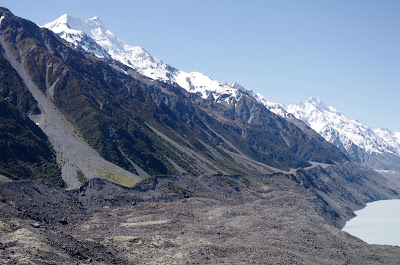 |
| The moraine in the foreground was left behind as the glacier retreated (photo by John) |
 |
| The Tasman Glacier is at the end of the melt-lake (photo by John) |
John took the photo below in 1965, when it was possible for tourists to go on a guided glacier walk. This was well up on the glacier, a long way from its terminal. The dark ridge coming down from the top left of the photo below, is the same as the darker ridge just below the peak furthest to the left on the above photo. The glacier has retreated substantially since then.
 |
| A walk on the Tasman Glacier in 1965 (photo by John) |
Walking down was almost harder than going up, especially where the steps were not yet finished. I ended up walking on a narrow track alongside the steps instead.
 |
| John next to a clump of matagouri |
 |
| The fierce beauty of matagouri |
Back on the valley floor there was a large area of
“Spaniards", another very spiky plant. Not only does it have lethally sharp points on the ends of the leaves, but the flowers are also full of nasty spikes.
On the way back to SH8, towards Twizel, we stopped a couple more times to look back at the valley and at Mount Cook. We had been very fortunate to be here on such a lovely day.
 |
| The Tasman River Valley with Mount Cook and Mount Tasman (photo by John) |
 |
| One last look at Mount Cook |
Day 5 – Twizel River Track and Lake Ruataniwha
Monday 30 November. Now in Twizel, we first rode into the town centre to find the I-Site, where we enquired about biking tracks in the area and bought several maps – for walking and mountain biking. The walking tracks apparently are supposed to be bike-able. The mountain bike tracks were probably beyond both our and our bikes’ capacities.
We had coffee at Shawty’s Café – good coffee and nice scones, but the sparrows were an absolute menace. We had to keep flapping hands, jackets and stamping our feet to shoo them away, but they were very persistent, so we didn’t linger too long.
 |
| Shawty’s is the place with the red umbrellas (photo by John) |
Over coffee we decided to try the Twizel River Track. We had a bit of trouble finding it at first, but eventually found it. It must be said – the track is absolutely horrible to ride. At first it was a rough as guts gravel road for several hundred metres. My bike got shaken about so much that the chain came off. John had discovered a track that was more earthy than rocky that veered to the left, and I was lagging behind a bit, so I had to call out to him to come back and sort it out for me (I don’t touch such things, that’s what my clever in-house mechanic is for!).
The track arrived near the river, and the place was very pretty. A fairly swiftly flowing wide stream (or narrow river), with lots of gorgeous lupins in the gravel on the opposite bank.
 |
| The Twizel River … (photo by John) |
 |
| … and the lupins ... (photo by John) |
 |
| ... and still more lupins (photo by John) |
We were delighted with al the lupins and took heaps of photos, but I cursed a lot at the track. It became just a narrow rut in places, and very stony in others. I had a few adrenalin surges, as my wheel caught the edge of the rut, which upset my balance, and I needed to adjust or fall. I didn't fall, but had plenty of “exciting” moments.
 |
| The track became a narrow rut in places (photo by John) |
 |
| Here the track simply falls off the edge, where the bank has been scoured out (photo by John) |
 |
| Suddenly there was yellow among the pinks and purples: Californian poppies |
After a while, the track went under and beside large willows, on a grassy rutted surface. It was very pretty under the willows, with lovely views through the willows and across the river towards the lupins.
 |
| The grassy track under the willows (photo by John) |
 |
| Looks like the effects of recent flooding (photo by John) |
Because the track was so awful to ride on, progress was very slow. We were using level 1 assist, or no assist at all. Eventually we came to a place where we had to cross a side stream. Not deep, but wider than a “jump” span, and no foot holds, so we had to choose whether to get our feet and shoes wet, or to return the way we came. We did the latter. We didn't think the track quality would improve – it would have been OK to walk, but it really was no good for biking.
 |
| Californian poppies (photo by John) |
 |
| Woolly mullein at the water’s edge |
 |
| The river is not so deep and wide here |
 |
| We never made it to the Hobo’s Camp |
We had biked 13 km over two hours on a rather grotty track. We decided to ride towards Lake Ruataniwha in the afternoon, but first: lunch. We stopped at Poppies Café, where we parked our bikes right next to four beautiful Harleys. John took a photo of me between my bike and a Harley. It looks just like it’s mine!
 |
| Folding bikes or Harleys? |
About 2 pm, we cycled along Ostler Road towards Lake Ruataniwha – so nice to be riding on a smooth surface! – and turned right onto Max Smith Drive as we got to the lake.
 |
| Lake Ruataniwha – on the left is a small island (photo by John) |
Lake Ruataniwha is an artificial lake, which was created in the late 1970s as part of the Waitaki Hydroelectric project, in a gorge of the Ohau River.It is also the venue for many major rowing regattas every year. Max Smith, whom the road around the lake was named after, was the Ministry of Works Project Manager for the Upper Waitaki hydroelectric scheme. He promoted the idea of a rowing course on this new lake.
We rode various tracks around the lake – all rather stony and not particularly comfortable to bike. As we arrived at a large motor camp and camping ground, we met a Canadian cyclist who arrived at the same time as us, her bike laden down with gear, including a tent, I suspect, as she was asking about camping spots, away from the camper vans. She said she needed to be able to sleep, away from other people’s noise, as she had biked up from Cromwell that day. Wow! that’s about 140 km! The mind boggles …
We stopped at the shop for an ice-cream. As John was taking a picture of me with my ice cream (one for Elaine!), a chap bringing his coffee cup to the long table at with we were sitting offered to take a picture of us together.
 |
| Ice creams at the Lake Ruataniwha motor camp |
It turned out he was the owner of the motor camp. The camp was full, he said, but there was nobody around! I suppose people would be arriving later in the afternoon.
He pointed us towards further tracks around the lake that we could ride. We did a circumnavigation of the camp first. There were a lot of stationary caravans, with shelters or sheds next to them. I assume these are the regular holiday places for people in Timaru or other centres? The motor camp also provides accommodation for all those attending the rowing races on the lake.
The track we followed beside the lake was reasonable, and rather pretty, with trees by the edge, and views across the lake.
 |
| View of from the lakeside track (photo by John) |
At the end of it we came to the place where the rowing races set off from – with a viewing tower, and “starting blocks” for the rowing crews and marked-out lanes on the water.
 |
| The rowers’ racing venue and “starting blocks” |
From there, we went on the road (SH8), across the Ruataniwha spillway. This is the structure that controls the outflow of the Ohau river from the lake.
 |
| The Ruataniwha spillway |
 |
| The Ohau River – not much water is flowing out of the lake today |
 |
| On the other side of the spillway was this salmon farm (photo by John) |
We went across the road, and tried another track that was supposed to lead to Ben Ohau. But we only went a short distance, as the main track was very rough gravel, and the soft track beside it soon ran out. We didn’t want to do more rough stuff, so we headed back into Twizel on the road – about 4 km.
We did 32 km today. Quite respectable really, considering much of it was on lousy surfaces.


I like your description of the matagouri's "fierce beauty". It reminds me of a Yeats' poem with the lines "a terrible beauty is born".
ReplyDeleteThanks Pat
Delete