Last Friday, 15 April, it was a cloudless and calm day – or so we thought – and it seemed like a perfect day for a bike ride. We thought we would bike around the whole of the Miramar Peninsula. So I skipped my Zumba class and we headed into town to park near Greta Point.
It turned out we had misjudged the weather slightly. Driving into town, we could see there were clouds hovering over the city and Miramar, and when we got our bikes out of the car, we found there was a brisk southerly. It is a bit deceptive – living, as we do, in the lee of a hill that shelters us from the southerly, we weren’t aware that there was any wind at all. Not to worry, we came prepared – our soft shell windproof jackets kept the wind out, and our bodies warm.
The saga of John’s back-facing camera (iPhone) continues. He bought a “selfie stick” – amazingly, those things are available at the supermarket these days! Not because he wanted to indulge in taking selfies, but because he wanted the phone-holding bracket on the end of the stick, and the blue-tooth remote control gadget that came with it. So he’s now attached the bracket under his saddle – facing the back, of course – and the remote control device on his handlebar, so he’s able to take single rear-facing photos when we are riding in an interesting place. He uses his rear-view mirror to see what he will be snapping.
 |
| John mounted his iPhone below his saddle. It can be charged from the bike's battery (photo by John) |
However, he forgot to take his regular camera, which he normally mounts on his handlebar. So for one thing, we have far too many rear-facing shots (of me mostly, which I won’t subject you to), and for another thing, when he wanted to take a stationary photo, he had to turn his bike around, because his only camera was facing the back! Still, he managed to get some good photos …
At Greta Point, near where we parked, there is a long, disused jetty, on which a large number of white-fronted terns had taken up temporary residence. There were hundreds of them. Of course, John had to turn his bike around, to be able to take the shot below.
 |
| A colony of white-fronted terns (photo by John) |
We biked along Evans Bay Parade and Cobham Drive to the Miramar Cutting, from where we set off on the circumnavigation of the Miramar Peninsula.
 |
| Shelly Bay Road (photo by John) |
 |
| Just before Shelly Bay (photo by John) |
At the northernmost point of the peninsula is the Point Halswell Lighthouse. At low tide, it is possible to walk across a concrete ramp to the lighthouse, but this time the tide was up, and it was surrounded by water.
 |
| The Point Halswell Lighthouse (photo by John) |
While John was taking a photo of the lighthouse, another cyclist pulled up, ready for a chat. He asked us about our bikes, and then told us he had biked from Upper Hutt, was going around Miramar and then would bike back. That is quite a distance. At my question whether his was an e-bike as well, he scoffed. No, he said, he biked 125 km “the other day”, and 200 km the day before that. Then he casually mentioned that he’d competed in the Seoul Olympics (1988), in the 1km time trial.
Wow, a real live Olympic competitor! His name was Tony Graham. He said he came in 7th. But, he said, three guys from the Eastern bloc were probably "on something”, so he reckoned he was really 4th.
 |
| Tony Graham, Olympic cyclist, and little old me … |
After a pleasant chat, he took off into the headwind, saying we’d probably catch up with him on our e-bikes. We pedalled off too, but then John’s competitive instinct got the better of him, and he took off in pursuit. He cranked the e-assist up to the max, and pedalled like hell, and overtook Tony for a brief moment. I laughed when he took off, and teased him when I caught up with him a bit later. “I just wanted to see if I could do it”, John said. Well, there’s life in the old boy yet!
 |
| This is where John overtook Tony, then waited for me to catch up with him (photo by John) |
 |
| One end of Scorching Bay (photo by John) |
We carried on around the peninsula – Scorching Bay, Karaka Bay, Worser Bay, Seatoun. We checked out Franco’s Trattoria in Seatoun for lunch, but the place had closed down. Newspaper covered the windows, and a sign announced the opening of a differently named café soon. Oh well, we pushed on, we would try for lunch at the Spruce Goose in Lyall Bay. Through Seatoun, up and over the Pass of Branda, and on to Breaker Bay.
 |
| Down the hill after the Pass of Branda (photo by John) |
Last time we rode along Breaker Bay (in February), there was work in progress to build a seawall, to protect the area from the waves during southerly storms, which appear to be getting more frequent and more destructive. Now the work is almost complete, and workmen are putting in the finishing touches.
 |
| The landward side of the seawall is getting its finishing touches (photo by John) |
 |
| The seawall consists of 2,300 tonnes of oversized rocks from the Wiremu Road Quarry, Mt Taranaki |
Down Breaker Bay Road, to Moa Point, past Rangitatau Park, where the track from the Ataturk Memorial high above joins the coastal road, and on through the tunnel under the airport runway at Lyall Bay.
 |
| The tunnel under the airport runway at Lyall Bay (photo by John) |
Our plan was to try the Spruce Goose for lunch. The café has a gorgeous view out to sea and over the airport, but when we got inside, it was so busy and so very noisy, that we left again. So on we pedalled to Elements Café on the corner of Onepu Road and Wha Street. Much quieter, and entertaining too, as we watched a road crew doing some work in the middle of the road. Lots of men in orange hi-viz jackets, and lots of road cones. It wasn’t really clear what the object of the exercise was, but no doubt the council has a good reason …
 |
| Lunch at Elements Café … (photo by John) |
 |
| … with entertainment thrown in … |
So far, we had completed our circumnavigation of the Miramar Peninsula, but we decided to carry on round the coast to Island Bay, and check out the new cycleway, that seems to have got so many people’s knickers in a twist.
We enjoy biking this bit of the South Coast. There is a nice cycle/footpath, and a boardwalk for some of the way. And I love the rocky foreshore and the blue sea, as it rolls onto the rocks and beaches with its white-capped waves – sometimes small and sedate, sometimes huge and wild.
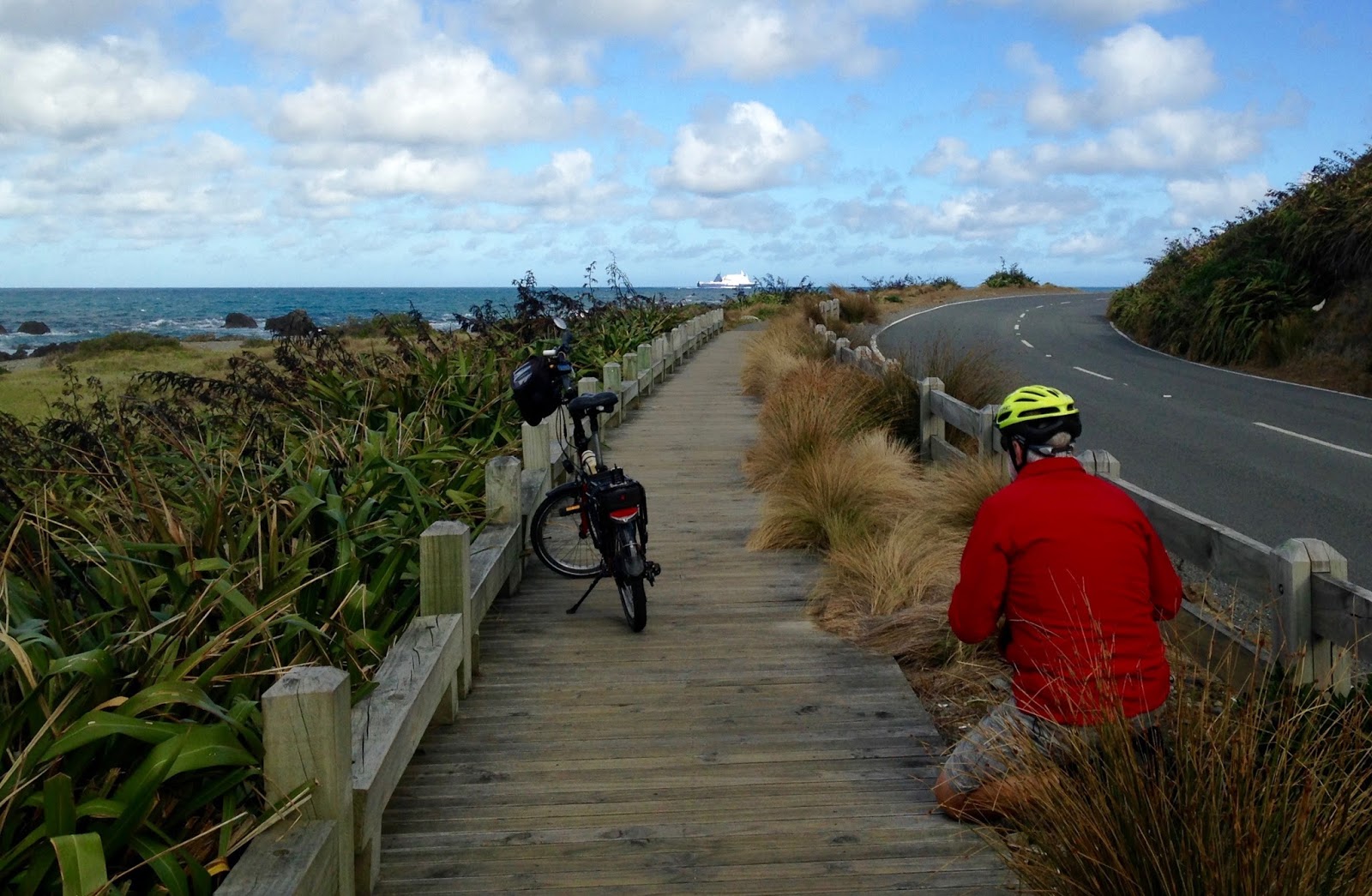 |
| I managed to snap John while he was crouching to get a low-angle shot of the boardwalk, the grasses, and his bike |
 |
| Looking the other way – Lyall Bay and the airport in the background (photo by John) |
 |
| Houghton Bay, with Taputeranga Island in the next bay (Island Bay) |
We rode the full length, there and back, of the newly completed Island Bay cycleway, which runs for 1.6 km on each side of the road.
It’s been very controversial, both during its construction, and now that it is completed. The aim of the cycle lane is to separate it completely from other traffic, by having parking between it and the road, making it safer for cyclists, especially children biking to school. But so that it does not interfere with bus stops on the road, it is made to go behind the bus shelters, which annoys the commuter cyclists because it slows them down.
 |
| The start of the Island Bay cycleway |
There have been bitter complaints both from the local community, many of whom are incensed to lose the nice wide road that The Parade used to be, and by some of the cycling fraternity who think that it is poorly designed.
We are not commuters, so we were not in a hurry. As such, we found the cycleway very pleasant to ride on and I felt very safe. It is wide, and it allows a “door space” – marked by a broken line – so that cyclists do not accidentally ride into passenger doors being suddenly opened into their path.
However, I can see why the local residents find it frustrating, as the cycleway takes up so much room on each side, that the centre lanes for the car and bus traffic are only just wide enough. In fact, I saw a bus going past, and it had to go over the centre line to clear the parked cars. Why did the council not take a chunk off the footpath, which is much wider than most footpaths need to be, especially if the pedestrians do not have to share it with cyclists. That would have left more room in the centre for car traffic.
 |
| The footpath is much wider than it needs to be (photo by John) |
 |
| Coming up to a diversion around a bus stop |
Having biked the cycleway in both directions, we headed back around the coast. Coming up to Lyall Bay, John stopped to take a photo of the rocks framed by some pohutukawas – a very nice view. While I was waiting for him, I saw some bits of rope around the trunks of a couple of trees, and on closer inspection, I discovered some knitted stars, strung between them – very crafty.
 |
| Rocks along the shore by Queen’s Drive (photo by John) |
 |
| Knitted stars between the trees |
From Lyall Bay, we made our way through the streets to Kilbirnie, and then along Evans Bay, back to the car. We'd had a lovely day, and biked 38 km.
No comments:
Post a Comment