Last Monday (3 February) was a glorious day – beautifully fine and no wind. Bliss! Perfect for us to have another go at the Rimutaka Rail Trail. We wanted to go a bit further than the Summit this time, go through the second tunnel, and see how “bad” the other side was.
Last time we went there, I refused to even entertain the thought of going beyond the Summit, having heard and read about how rough it is, and about a gully called “Siberia”, that is supposed to be terrible.
We set off from the carpark just after 11am, and it was just a steady push, imperceptibly uphill. The incline is so deceptive – from looking at it, you’d swear it was flat. But while biking it, you know you are going uphill, as you have to go down a gear or two.
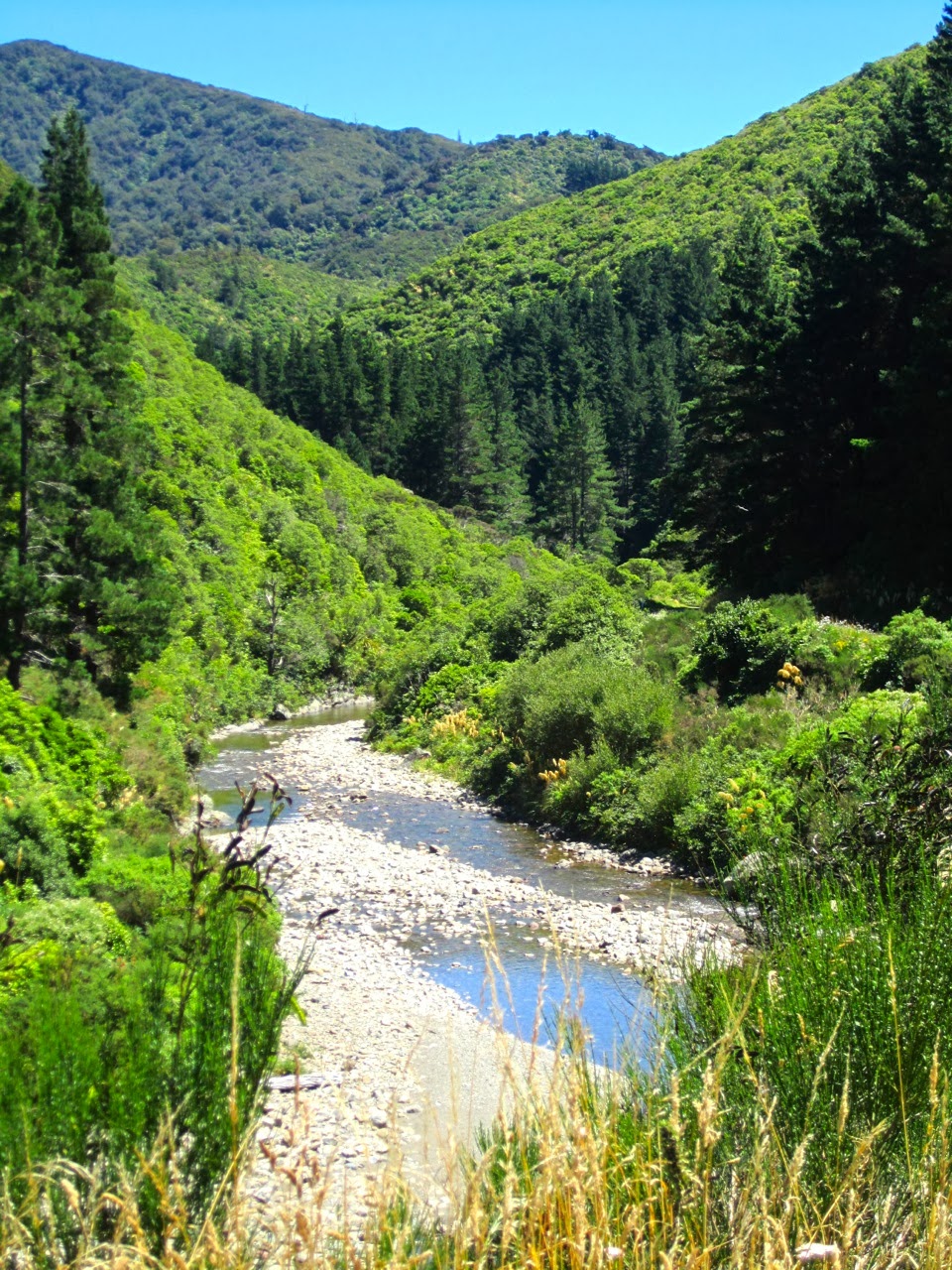
We didn’t make many stops for photos on the way up since we’d been here before. But John did take a photo of the toetoe that grow in great swathes and their fluffy plumes stand out as creamy white patches among the multitude of greens.
 |
| Patches of toetoe among the many greens of the hills (photo by John) |
At 73 metres, the Pakuratahi Tunnel is just a short one. It is built on a slight curve, but you can still see the exit right from the entrance.
 |
| John obligingly waited for me to take this photo, as we emerged from the Pakuratahi Tunnel |
Soon after the tunnel, we came to the Pakuratahi Bridge. It is the oldest truss bridge in New Zealand. Originally built in 1876, it was rebuilt in 1910 after a fire, and restored in 2002.
 |
| Some of the huge timbers of the Pakuratahi Bridge, and the heavy iron plates holding them together |
It took just over an hour to get to the Summit. This is a wide open space where, in the days of the railway, the engines would be changed before tackling the steeper track on the Wairarapa side of the hill.
We stopped for a breather and walked up to the area where railway workers’ cottages once stood. A few fireplaces remain.
 |
| One of the old fireplaces has been split by the large tree growing right behind it |
From the top of the bank we had a nice view back to the Summit shelter. We had the place completely to ourselves. Apart from the occasional bird call, there was perfect silence.
 |
| The Summit shelter, which houses displays about the history of the Rimutaka railway (photo by John) |
One of the old pine trees took my eye. Part of the bank had crumbled away and exposed the roots. I liked the texture of the bark and the colours of the moss growing on it.
 |
| The old pine tree’s wonderfully textural bark |
Back on the bikes, and from here it was new territory. We pushed on and very soon we came to the Summit Tunnel. This is a long tunnel – 584 m long – and though it is straight, and you can see the “light at the end of the tunnel” all the way through, it is absolutely pitch black in there. It pays to have a GOOD torch with you. A piddly little one from the $2 shop will not do.
 |
| The mossy stones at the entrance to the Summit Tunnel |
 |
| John is adjusting his torch before entering the tunnel |
John had packed one reasonably good torch, and one that turned out to be pretty feeble. The tunnel was not an enjoyable experience. It was pretty daunting for John especially, because with his impaired balance (a result of brain surgery), he relies on visual cues to keep him upright and going straight. In the dark it was not possible to bike through the tunnel, so John walked ahead of me, with the better torch, and using his bike as a support.
To begin with, I lagged behind a bit, but my torch was so feeble that it only had just enough oomph to light the ground right in front of my front wheel, not further ahead. So I tried to stick close behind him, so that I could benefit – sort of – from his torch shining on the path ahead. We could hear the water dripping from the roof, and down the walls. There were quite a few puddles along the edges, that John could see but I couldn’t so he would warn me of the puddles coming up.
Six-hundred-odd meters in the dark seemed like a long, long way. Poor John was feeling quite disoriented, and suffering serious nausea from the imbalance (like being sea-sick). He was quite relieved when we came out into the light and fresh air. I’m pleased to say he was still able to take photos after that and to get back on the bike too.
We thought the track might be OK-ish for a bit after the tunnel, before deteriorating at “Siberia”. But it wasn’t. It was quite rough right away, and steeper downhill than I would like – bearing in mind that if you go downhill one way, you’ve got to struggle back up the hill coming back!
 |
| On exiting the tunnel, the track was noticeably rougher and steeper |
This is where the “Rimutaka Incline” started. This section of the train track has an average grade of 1 in 15 – too steep for a regular engine to pull up, so in in the early days, the train would be pulled up – or down – by Fell engines. The Summit area is where the engines would be changed from regular engines to Fell engines.
The Fell system uses a raised centre rail between the two running rails to provide extra traction and braking, or braking alone.
 |
| The information panel at the exit of the Summit tunnel |
John, having recovered from the worst of the effects of the tunnel, had biked off ahead of me, down this awful steep and rough track. I – the scaredy cat – tried to follow, skidding about on the rough gravel and hanging on to my brakes for dear life and yelling “I don’t like this! Stop! I don’t like this!” After a bit John also thought it was a bit too rough for his liking, and suggested we turn around and go back. He biked up the hill. Not me – I walked up, puffing and panting …
Then we had to go through the tunnel ordeal again! So much for trying to go down the “other side” of the Rimutaka Rail Trail.
 |
| We had to go back through the tunnel again! (photo by John) |
Back at the Summit, we stopped to talk to a lone British cyclist. He was half-way through a four-month cycling tour of New Zealand. He had biked from the far North and done all the interesting cycle trails. This was the last of the North Island trails, and he was heading to the South Island in a few days’ time. He was ecstatic about the Rimutaka trail – about the magnificence of the landscape and about the excellence of the track. He was heading towards the second tunnel, so we warned him that the next section of the track would be a bit rougher.
Now, on our way back, it was lovely to tootle downhill – on a nice smooth track! We stopped briefly on the Ladle Bend Bridge to take photos.
 |
| Ladle Bend Bridge (photo by John) |
 |
| The Pakuratahi River at Ladle Bend |
It was so still, that I could hear a slight crackling sound as the ripe pods of the roadside broom burst open in the warmth of the sun!
 |
| Ripe broom pods crackled as they burst open in the heat |
 |
| Different varieties of ferns along the edge of the track |
We stopped to enjoy a Whittaker’s mini slab (of chocolate) at the Munitions Bend Bridge. The original bridge was partly washed out in the 1960s, and its remaining abutments were restored in 2004, when the new footbridge was built. We discovered a section of old railway track next to the bridge, that we hadn’t noticed before.
 |
| Munitions Bend is a pleasant spot for a rest |
 |
| A section of railway track was left beside the new footbridge |
 |
| The new footbridge straddles the original abutments (photo by John) |
From here it wasn’t very far to get back to the car. It was about 2:30 pm, and we had ridden 22 kms. Apart from the scary bit after the second tunnel, it had been a most satisfying ride.
No comments:
Post a Comment