We’re already into the New Year as I write this up, so I am have some serious catching up to do.
Back in November, during a ride to Waikanae, we got very excited about the yellow lupins that were in full bloom. That triggered the decision to take a biking trip to the Mackenzie Country and beyond, to see the multicoloured lupins that the area is famous for.
It was a great trip, during which we took a LOT of photos, and so I have had to write this trip up in four parts. This is where you’ll find Part 1, Part 2, and Part 3.
Day 8 – Wanaka
Thursday 3 December. Today we were driving to our next destination, Wanaka. As we left Twizel, it started spitting (raining) off and on, until we got to Omarama, where we stopped for coffee at the Wrinkly Rams Café. We couldn't believe the number of camper vans in the car park, yet there weren’t that many people in the café. Perhaps they were all attending the “Sheep Show” which this place puts on.
 |
| There were some magnificent peonies lining the wall around the Wrinkly Rams Café (photo by John) |
When we left Omarama, the rain really set in. Very disappointing, because there were such wonderful views of lupins everywhere – along the road, and in river beds. Before the road climbs towards the Lindis Pass, it skirts the Ahuriri River. In the riverbed, we could see huge swathes of lupins. We stopped by a gate that gave access to a track down to the river. Unfortunately, because it was raining, we didn’t go down there.
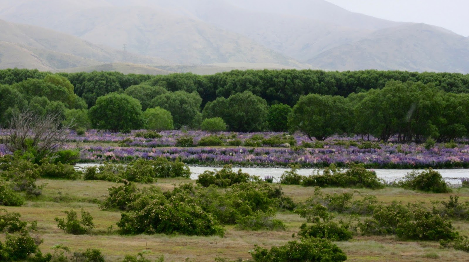 |
| Lupins in the Auhuriri riverbed |
As we got closer to the Lindis Pass, the lupins became more and more prolific. I didn't realise that they were a feature of the Lindis Pass until a friend mentioned it when I told her of our planned holiday. It was such a shame that it was raining and a bit misty. The hills of the pass are so beautiful and they would have been so good in the sunshine. We hoped it would be better on our return trip.
By the time we reached Wanaka, the rain had all but stopped. We found our way to the house we had rented for the next few days, unloaded our stuff, then went in search of lunch in the township.
Stomachs satisfied, we went for a drive towards Glendhu Bay, but then decided perhaps we should bike instead of drive, as there is a track along the waterfront. We parked under the willows and unpacked the bikes.
 |
| We parked under the willows |
The track is very nice to begin with. We went past the Edgewater Lake Wanaka Resort, which looked very swish. There were lovely views over the lake, with a lot of yellow lupins along the shore, but so far, no blue or purple ones.
 |
| Lovely views of the lake … (photo by John) |
 |
| … with yellow lupins on the shore and Ruby Island in the lake |
At Waterfall Creek, the track crossed Ruby Island Road, and it became rougher, and started to climb. The Kennetts' book mentions that the track continues to Glendhu Bay, but that it becomes very steep with large drop-offs to the lake on the side. We did try going up one rise which was very steep and lumpy and quite hard work, even with the e-bikes.
 |
| Near Waterfall Creek, just before the climb (photo by John) |
So we turned around and rode along the lakeshore on the other side of the town, past the yacht club and towards Eely Point.
 |
| Along the lakeshore in front of the Wanaka township (photo by John) |
 |
| The Wanaka Yacht Club marina |
After the Yacht Club, the shared foot/cycle path, became a track, below Lakeside Road. It ran under lovely trees, and here we saw lots of purple and pink lupins, as well as a sprinkling of yellow ones.
 |
| Some of these purple lupins had already gone to seed (photo by John) |
A somewhat incongruous sight was the yachts and catamarans that had been pulled up on the shore, under the trees. Some looked as though they had been there for quite some time, judging from the vegetation around them. It wondered how the owners would extricate the masts from the tree branches.
 |
| Yacht and catamaran pulled up into the shrubbery (photo by John) |
We rode as far as the Eely Point Reserve, then went back to the car. We sat in the sun at the lake’s edge, now that most of the clouds had disappeared. Very lovely.
 |
| Enjoying the lakeshore in the sun (photo by John) |
Day 9 – The Hawea River Track
Friday 4 December. We did another of the rides described in the Kennetts’ book, the Hawea River track. But rather than driving to Albert Town to the start of the track, we biked from our accommodation around Beacon Point and along the Wanaka Outlet Track.
The lakeside track continues from Eely Point, where we turned around the previous day. It is very pretty along here, and again, we found ourselves in the midst of colourful lupins.
 |
| More lupins, and flowering cabbage trees, on the lakeside track (photo by John) |
The latter part of this bit of track was quite lumpy and stony. But it got worse on the Outlet Track. It runs alongside the Clutha River as it exits Lake Wanaka. The track was up and down and very lumpy-bumpy over big stones and tree roots, and very narrow just above the river which was running quite high, and quite fast. It was really a mountain bike track, and I am rather a wussy scaredy cat on tracks like that.
 |
| The Outlet Track went up and down … |
 |
| … and was narrow and uneven … (photo by John) |
 |
| … with a drop to the fast-flowing Clutha on our left |
It was very pretty by the river, but the water was running high, and the track was narrow, with a steep drop on the left to the river below, and a high bank on the right. You had to concentrate and keep your eye on the track, if you didn't want to keel off the edge. So you couldn’t really afford to do too much looking around. In some places we had to push the bikes uphill over lumpy tree roots.
 |
| Track clearing in progress? |
Eventually we emerged from the track, near Albert Town, where the Clutha widens, as it is joined by the Hawea River.
 |
| The Clutha is quite wide at this point (photo by John) |
I really did not like this part of the ride, the bumpiness was very hard on the body and bike, and it made my hands hurt quite badly. So by the time we reached Albert Town, I was feeling sore and grumpy. We stopped at a pub/cafe/store for coffee and scones and felt a bit restored, before carrying on towards Hawea. We had to ask the waiter at the café how to get to the track, as it was not very well signposted.
He told us to cross the road bridge, turn right onto a dirt road for about a kilometre, past a camp ground and we would get to the swing bridge over the Hawea River, which marked the start of the track.
The dirt road was confusing, as there were several strands to it. Fortunately John has an innate sense of direction.
The swing bridge was a bit of a challenge, as we had to scale two flights of steps to get up onto it. There was a board along the right hand side to wheel your bike up. While we were debating how best to go about this, another cyclist came along and he took it in his stride. With a lightweight carbon fibre bike, he just lifted it and wheeled it up the ramp.
As our electric bikes are quite heavy, it needed both of us to lift one bike up onto the ramp, and John used the walk-assist to push it up the ramp. I followed and helped him up the next flight. Then we had to go back and get the other bike.
 |
| Getting the bikes up onto the swing bridge was a bit of a mission |
 |
| Nearly there... |
Getting across the swing bridge was interesting. John walked his bike because the narrowness affects his balance, and as it was quite a long bridge, it bounced to his steps. I decided to bike, as the last time I walked across a swing bridge (in Arrowtown) the movement freaked me out a bit.
 |
| It was quite a long swing bridge |
 |
| John walked it … |
 |
| … but I biked it (photo by John) |
The track from there to Hawea was much nicer than the Outlet Track, though still fairly stony. It went along the Hawea River – not such a scary river as the Clutha. Very pretty too.
 |
| The Hawea River track was more pleasant to bike along |
 |
| The Hawea River |
About half-way to Hawea, we crossed Camp Hill Road, and arrived at "The Wave", or Hawea Whitewater Park. This is a part of the river that has a specially designed community facility for kayakers and other whitewater thrill seekers.
 |
| The first (or rather, the last) of the rapids of “The Wave” looked very benign today (photo by John) |
 |
| The Whitewater Park sign (click on the photo to enlarge it) |
The river looked very benign, but on “release days”, large volumes of water are released from the dam at the outlet of the river from Lake Hawea. The water, which takes up to an hour to arrive at the Whitewater Park, provides “two river-waves for kayakers, bodyboarders, surfers, and rafters to surf, play and train on”.
On 15 December, we saw a report on TV’s “Seven Sharp” about one such release day. Take a look. The river looks very different in it.
As we got closer to the dam, the track ran alongside an apparent water race of sorts. We didn’t discover the function of it – it was narrow, and shallow, and water ran down it in a very peaceful way. It struck me that it would be ideal for children to play in, but there was no-one around.
 |
| A shallow water channel ran from near the dam to the Hawea River (photo by John) |
 |
| The source of the water channel exits from below the dam (photo by John) |
 |
| The dam between Lake Hawea and the Hawea River outlet (photo by John) |
The Hawea Dam is part of the Roxburgh hydroelectric power scheme.
 |
| The other side of the Hawea Dam (photo by John) |
 |
| Lake Hawea |
We made our way into Hawea village, where we had lunch in the only general store-cum-café, called “Sailz”. We decided to return by the road, rather than the track. It would be shorter and not so bumpy on my hands, but we found that there was quite a lot of car traffic.
As we came back into Wanaka suburbia, and were about to cross a road, we kind of came to grief. John had stopped, waiting for a car to go past. As I was looking at the same car, I bumped into John, who was stationary in front of me. He lost his balance, I tried to catch him and lost my balance too. We ended up in a bit of a mangled pile – on the road-side track luckily, not on the road.
Of course John was furious. He said it was all my fault! “Didn’t you see me?” “No, I was looking at the car! You stopped right in front of me!” So we were both pretty grumpy with each other, and hot and bothered, by the time we got back to the house.
After coffee and a cool off, we went for a drive towards the Matukituki Valley, but didn't get too far, as John discovered we didn’t have a lot of fuel left, so we went back into town. After sitting on the rocks by the water for a while, we went and had a pizza for dinner, and then headed back to the house.
 |
| Late afternoon by Lake Wanaka (photo by John) |
Day 10 – The Matukituki Valley
Saturday 5 December. Having had our little mishap the previous day, and with both of us feeling a bit “biked out” after having biked just over 300 km in the past week, we decided not to go for any more bike rides, but to go for a drive instead.
We packed some bread rolls and bananas for a picnic, and set off for the Matukituki Valley. It was much cooler, rather windy, and partly cloudy. The road to Glendhu Bay is lovely – there is a Glendhu Bluff Conservation Reserve, which has very impressive cliffs.
The Matukituki Valley is very wide, resulting from long-ago glacier action, with the braided river running down from the mountains near Mt Aspiring to Lake Wanaka. We visited here in May 1968, and my enduring memory of it was its vast, green width.
 |
| We slowed down for this group of cattle on the move. The tiny red dot on the left is the farmer |
After the turn-off to the Treble Cone Skifield, the road became gravel. It wasn't too bad, though John had to drive at only about 25 km/hr. He suggested a couple of times that “it’s not too bad, OK for biking, do you want to give it a try?” No, I didn’t.
There were cattle beside the road, looking very peaceful, many cows with calves. Nice to see after the horrible story on TV the previous night about how a few Waikato farmers maltreated their bobby calves. We also saw sheep with lambs, and a couple of paddocks with deer.
 |
| I love the way cattle follow you with their stares |
At one place where there were exposed rocks, there were parked cars and people climbing on the rocks – some with and some without ropes. I would have liked to stop and watch, but we didn’t. Rock climbing is not something I would want to do, it would give me the heebie-jeebies. But it is kind of thrilling to watch, even if it makes your stomach twitch.
The Matukituki River was quite distant, and we could see that the wind was stirring up the dust in the river flats. We didn't get to see Mt Aspiring, which one is supposed to be able to see from the top of the valley, as it was shrouded in mist and cloud.
 |
| The wind was stirring up the dust in the river flats |
 |
| Mt Aspiring is up there, somewhere … (photo by John) |
After a long while we turned around and went back. We stopped at several places to take photos of amazing geological features.
 |
| Brooding hillsides |
 |
| The big rock seems to be delicately balanced to stay in place on the scree slope (photo by John) |
 |
| These grass-covered rocks look like animal faces (photo by John) |
 |
| This pretty stream is called “Big Boggy Burn” |
We stopped by a group of farm buildings, where a whole row of old agricultural implements (ploughs, threshers and other stuff I couldn’t name) were all lined up along the fence.
 |
| A display of old farm machinery (photo by John) |
 |
| I liked the colours of these lichens growing on a fence post |
 |
| A last look up the valley (photo by John) |
Days 11 – The Lindis Pass
Sunday 6 December. It was time to go home. We were very glad that it was a nice sunny day, as we were going to head north over the Lindis Pass, where we were looking forward to taking photos of the amazing lupins beside the road and in riverbeds. We were not disappointed.
What a fantastic, colourful spectacle! Just one difficulty: which photos to select to show here.
 |
| Swathes of lupins beside the road … (photo by John) |
 |
| … and by the river (photo by John) |
 |
| The previous night’s rain drops still sit on the leaves (photo by John) |
 |
| Close up (photo by John) |
After a dip into a valley and a bend in the road we stopped again to photograph a whole valley in glorious colours.
 |
| The whole valley was covered in lupins (photo by John) |
 |
| Beside a pretty stream (photo by John) |
 |
| A last look before pushing on (photo by John) |
At the top of the Lindis Pass, the landscape changed completely. Gone were the valleys with lupins. Now there were tussock-covered hills, with a wonderful velvety look.
 |
| The hills at the top of the Lindis Pass |
 |
| There were just a few clumps of lupins between the road and the tussocks (photo by John) |
 |
| I love the texture on those hills (photo by John) |
 |
| Heading down out of the Lindis |
We stopped briefly at the Lake Pukaki Information Centre, for a comfort stop and a few more photos.
 |
| Rocks, Lake Pukaki, and mountains (photo by John) |
 |
| The “icons” of this trip: lupins, the A2O, and Mount Cook |
After this we pretty much kept going, until we got to Kaikoura, where we stayed the night. The next day, we drove to Picton and the 2pm ferry delivered us into the peak-hour traffic in Wellington. We were home by 7pm.
It had been a great holiday, but as always, it’s nice to get home to your own bed.
No comments:
Post a Comment