Showing posts with label vineyard. Show all posts

Thursday, 12 December 2013

Hawke's Bay Cycle Trails – Days 5 & 6


Recently we went to Hawke’s Bay for a few days’ riding the wonderful cycling trails in the region. This post is about day 5. You can check out days 1& 2 here, day 3 here, and day 4 here.

Day 5 – Monday 2 December
The Puketapu Loop, and a drive to Waimarama

In the previous three days of cycling, we had ridden 120 kms, so on this last day, we decided to take it a bit easier, and bike the Puketapu Loop, which is only 18 kms.

We rode this track last March, when I had only just started biking, and I had such a lot of trouble with the hill by the Puketapu Pub, that John thought that we should do it the other way round this time, and avoid the worst of the hill.

The track starts at the Pettygrew Green Arena, from where we headed onto the stopbank, turned right, and crossed the bridge.

This is a really lovely trail. The landscape is quite varied, from river, to corn fields, to crops of various kinds; orchards of apricots, cherries, and kiwifruit; vineyards; and also trees and bush.

It was not very windy, just breezy enough to stop it getting too hot. In some places, clumps of trees near the track looked very inviting, and I thought that we should have brought a picnic rug, some lunch and our books. It would have been nice to lounge and read under the trees for a while …

It would have been nice to lie in the shade of these trees, with a good book … (photo by John)

Other bushy areas were just very pleasant to ride through, even if we had to negotiate a fallen tree.

The track ran under lovely trees (photo by John)

I wonder if this tree came down in Saturday’s galeforce winds (photo by John)

It wasn’t long before we arrived at Puketapu – a small settlement with a pub and a store – the half-way mark of the Puketapu Loop. John suggested we stop at the pub for a coffee, but I remembered the definitely mediocre coffee (and very so-so lunch) we’d had there in March, so we opted for an icecream cone from the shop instead. 

Icecream cones in front of the Puketapu Store (photo by John, with his camera fixed on his bike!)

We sat on the seat in the shade in front of the shop, and enjoyed our icecreams. I looked at the gradient of the road in front of us, that had caused me so much trouble last March. It now didn’t seem to be so terrible. I have definitely progressed!

Quite soon after Puketapu, we came to a beautiful park with a small lake, with a jetty and several small islands, and grazing sheep. It looked so lovely we crossed over the cattle stop and went in for a look. We thought we might be able to ride around the lake. There was a picturesque stone bridge, but as we rode over it, and headed up the track beyond it, we suddenly became aware that this was probably not a public park, but a private property. There had been nothing to say so at the entrance, but we thought we had better not go any further.

Such a pretty little stone bridge (photo by John)

Oh, to own such a beautiful property! (photo by John)

We have just used Google Maps on “streetview” to look at the entrance, and we discovered that the property is called “Bridgewater”. The name is on the fence by the entrance, but we didn’t notice it at the time. Isn’t Google amazing?

So back on the track, which soon crossed the road, and went back onto the stopbank, past vineyards and orchards, and into more lovely shady lanes.

Beautiful gum trees … (photo by John)

… and shady lanes (photo by John)

It was an easy 18km ride, very enjoyable, and by 12:30 we were back at the car. We went into Havelock North for lunch, and then had a walk and window-shop around Havelock. It really is a very pleasant small town.

With the afternoon ahead of us and no biking to do, we drove up to Te Mata Peak. Driving up the section of Waimarama Road that was part of the Tukituki Loop which we had biked two days earlier, it actually looked worse than when we were riding it. Perhaps it was just as well that I hadn’t been up there by car before biking it, because I am sure I would have told John to “forget it!”.

From Te Mata Peak, the highest point of the Craggy Range, the view is spectacular, over the river and the hills and the sea beyond. We looked down onto the Tukituki River, and much of the Tukituki Loop that we biked. Actually, I felt quite impressed with what we had done. That trail sure was a challenge, but seeing it from the top, it seemed quite amazing that I actually did it. We identified the hills where the road wriggled in and out of gullies that were such hard work.

The Craggy Range seen from its highest point, Te Mata Peak

From Te Mata Peak, we could see the Tukituki River, and beyond the hills to the sea. Craggy Range Winery is at bottom right of the picture (photo by John)

Red Bridge, from where the Tukituki Loop returns back down the valley (photo by John)

While we were at the top of Te Mata Peak, we talked to a retired Swedish couple who had walked up (wow!). They told us that they come to enjoy Hawke’s Bay’s summer for five months every year, to escape the Swedish winter. Rather nice!

We then carried on up Waimarama Road, and drove to Ocean Beach, where we took a walk along the water's edge. We are not really swimmers, and I certainly don’t like swimming in the sea (I hate the thought of being touched by creepy things floating about). But I took my sandals off and walked in the shallow water, until John noticed that there were jellyfish on the wet sand at that part of the beach. I made a quick retreat onto the dry! They didn’t seem to be everywhere though. It did look like a nice beach for surfing, and there were a few people swimming and playing on the beach.

Coming down the road towards Ocean Beach (photo by John)

Ocean Beach (photo by John)

Then back over the hill to the next beach at Waimarama. There is quite a settlement there, some 1960s or 1970s style houses, and some brand new big ones. Not a terribly attractive place, really, but I believe the beach is a very popular one. However, at the place where we turned around, by the exit of a stream, there was a sign warning that this part of the beach was dangerous for swimming.

Waimarama, but this part of the beach was not suitable for swimming (photo by John)

Bare Island, off the coast near Waimarama (photo by John)

On the way back, another view of Te Mata Peak (photo by John)

It was lovely driving in the countryside. New Zealand really is such a beautiful country. I can understand why overseas visitors rave about it. And aren’t we the lucky ones to be living here!


Day 6 – Tuesday 3 December
Going home


On Tuesday we made an early start on our way home. The trip was uneventful, except for a stop at the Clock Shop in Waipawa. The outside of the shop is very appealing (in a “twee” kind of way), and it caught our eye when we came through here in March. But it was closed that day, so this time we just had to stop and take a look inside.

The Clock Shop in Waipawa (photo by John, March 2013)

Wow, I don’t think I have ever seen such a huge variety of clocks and watches – ranging from very modern and colourful, to the kitschy and gimmicky, to cuckoo clocks of all kinds, to the old and venerable grandfather clocks.

The shop is owned by Jim and Anne Greeff. Jim is a British-trained horologist, and he repairs and restores clocks of all descriptions. He took time to talk to us, and show us around, telling us about some of the clocks. He showed us one grandfather clock of which he had repaired the movement. Sadly, the owners had got the case spraypainted a shiny jet-black, to fit in with their décor. It had once had a beautiful grain which was still visible under the paint, and I could tell from the way he talked that Jim did not approve of what they had done to the clock.

Jim and John got to discussing clock repairs and clock innards, and he told John that he was currently trying to fix a cuckoo clock with an electronic movement. It had fallen off the wall, and he was trying to figure out the mechanism that made the birdie come out, so he could fix it. He took John into his workshop, and the two of them pored over it, with John offering suggestions (he has a lot of experience with things electronic). I wanted to take a picture of them while they were both bent over this clock, but unfortunately Jim looked up at just the wrong moment.

How to fix this cuckoo clock? Jim looked up at just the wrong moment

After an interesting half hour in Waipawa, we headed to Woodville, where we had an early lunch at our favourite lunch stop – the Bridge Café – just before the Manawatu Gorge. Then, home. It had been a great holiday.

The Bridge Café, across the bridge, just before the Manawatu Gorge (photo by John)


Saturday, 7 December 2013

Hawke's Bay Cycle Trails – Days 1 & 2


Last week we went to Hawkes Bay for a few days’ riding the wonderful cycling trails in the region. I had been watching the long-range forecast for a week or so, and there was a window of four fine days wedged between a wet Thursday and the Tuesday when I had to be back in Wellington for a meeting. It worked out perfectly.

Day 1 – Thursday 28 November

The way up to Hastings sure was wet. A deluge, in fact. It started to rain when we were going through the Manawatu Gorge. The river was very high, muddy, and fast-flowing, and there was a lot of vegetation debris rushing down the stream. Between there and Waipukurau, the rain came down in torrents. The windscreen wipers were doing overtime, going as fast as they could, and every time a big truck (of which there were many!) went by in the opposite direction, it would throw up so much water, that we could barely see out. Fortunately, by the time we got to Hastings the rain had all but stopped.

I had booked a cottage through the holidayhouses website. I had twice before found lovely cottages through this website, and again, we were not disappointed.

“Arbor Vitae Cottage”, on the outskirts of Hastings, was perfect. It is in a beautiful setting. You enter the two-acre property through a beautiful garden, with an avenue of cherry trees leading past the main house. The cottage, separated from the house by a garage, is in its own small garden which you enter through a little gate, under an arbour of climbing jasmine. Box hedges on each side of the path, with an olive tree and other plants in the middle of each square. A terrace with a barbecue, table and chairs on one side and a seat and umbrella on the other side. The fence next to the garage was smothered in flowering star jasmine exuding a sweet perfume, which I will now associate forever with this holiday.

“Arbour Vitae Cottage” (photo by John)

Our “neighbours” were two sheep and three lambs, resident in the paddock next door. During our stay the lambs provided much entertainment with their antics. They had been born only a few days earlier, but were already quite boisterous, running around, climbing on one another and on their mums, and apparently feeding indiscriminately from either mother. We were amazed at how much they grew in the few days that we were there.

A peaceful, early morning scene in the paddock next door (photo by John)

Our “neighbours”. This photo was taken at sunset – the sheep are not actually pink (photo by John)


Day 2 – Friday 29 November
Napier Marine Parade to Ahuriri (part of the Coastal Ride), Taradale, Tutaekuri River-side track

After the torrential rains that had drenched Hawke’s Bay for the previous few days, Friday dawned as a gloriously beautiful day. Our plan was to ride on the cycle track along Napier’s Marine Parade, and carry on from there, in any one of the different options. We had a nice early start, we were biking before 9am (well …, that’s early for us!).

We parked the car at the southernmost end of Marine Parade, at the first carpark after the Winstone Aggregates plant. It was very bare and isolated, but the cycle track was smooth and a pleasure to ride on.

There was a strong surf at this wild, stony beach – and probably a strong rip too …

Next to the cycle track, at intervals, there were fitness stations consisting of bars at various heights, for exercises like sit-ups, chin-ups and other such tortures. Much more interesting were the three large “things” on the grass between the cycle track and the sea. We weren’t sure whether they were art statements, or whether they had some functional purpose. But they looked quite dramatic. (John has since done some research, and he thinks that they disguise vents for the Te Awa stormwater drainage system.)

Art or function? Or maybe both? (photo by John)

­­As we got closer to the Napier city centre, there were areas for people to rest or play – seating under canopies, water fountains, bike racks, barbecues, playgrounds. There is an enclosed “junior cycle track”, complete with mini-roads, traffic lights, traffic signs and pedestrian crossings. Right next to it is a seating area under a shade sail, from where parents can keep an eye on their kids. Further along there is a mini-golf course.

All this is new since the last time we visited Napier in March. The council is definitely wanting to attract more people to the area – perhaps as a response to the permanent closure of Marineland. The plans for the “Marine Parade Big Picture” sound quite extensive and exciting.

There are several sculptures along Marine Parade too. There is The Spirit of Napier, which stands atop a column over the Gilvray Fountain. The statue by Frank Szimay represents Napier rising from the ashes of the 1931 earthquake. It was unveiled in 1971.

The Spirit of Napier, by Frank Szirmay (photo by John)

Then there is the Millennium Arch, designed by Hawke’s Bay artist David Trubridge, which was commissioned to celebrate the start of the third Millennium in Napier. It depicts the rising of the sun over the sea towards Cape Kidnappers.

The Millennium Arch, by David Trubridge. What a shame about the hideous motels in the background … (photo by John)

A interesting bronze sculpture entitled The Trawlermen, is a feature on the forecourt of the National Aquarium, but unfortunately the light behind it did not make for a good picture.

Outside the iSite (Visitor Information Centre), the sculptured water feature by Para Matchitt is entitled The Heritage Fountain. The motifs reflect some of the things Hawke’s Bay is famous for – gannets, sunshine, rugged mountain ranges, sea and fish.

The Heritage Fountain, in front of the iSite (photo by John)

After we’d had a browse inside the information centre, we met a man with a most interesting bike. Actually we spotted his bike first, and John wanted to take a photo of it, because it was so quirky. Then the owner turned up, so we tried to talk to him. But it seemed that he couldn’t talk – perhaps he was deaf-mute. He mouthed, and pointed, and was obviously very proud of his bike, and delighted that we wanted to take a photo of him and his bike.

The bike was covered in cardboard, painted silver, held together with masses of duct tape. It had a plastic crate on the carrier – also painted silver – and had yellow cardboard tube “exhaust pipes”. Yellow “flames” on the side to give the impression of speed. I think he wanted to make his bike look like a motor bike. He proudly pointed at a shield on the front, with the dates 1978–2013 on it, and to a sign on the back of the crate that said “… to Invercargill” (I can’t remember what the dots stood for). It looked as if he had been on a very long bike trip from somewhere up north to the deep south.

You meet the most interesting people while biking (photo by John)

After that unusual encounter, we pushed on, below Napier’s famous Bluff Hill, past the port, and past the inner harbour at Ahuriri. There I watched the activities of a crew unloading crates of fish from a fishing boat into a truck marked “Hawke’s Bay Seafoods”.

Unloading the day’s catch

While I was doing this, John had gone on ahead, and photographed a Māori double-hulled sailing vessel. Upon searching for info about it on Google, I found out that this was Te Matau a Māui, one of seven waka hourua that spent 18 months traversing the Pacific Ocean. The aim of the voyage was to promote marine conservation, but it also focused on teaching and reviving traditional sailing and celestial navigation skills.  Interestingly, despite the intention to revive traditional sailing skills, it had a large bank of solar cells on its deck.

The waka is owned by Ngati Kahungunu Iwi, and is permanently berthed in the Ahuriri harbour.

Te Matau a Māui, a Māori double-hulled sailing vessel (waka hourua) (photo by John)

After this we went on a bit of a wild goose chase, trying to find a way round to the track that would lead us to Church Road. We ended up riding through unattractive streets that seemed to lead nowhere interesting, so we turned around and found our way back to the Boardwalk Café overlooking the beach at Ahuriri, where we stopped for coffee and a muffin.

Coffee at the Boardwalk Café at Ahuriri (photo by John)

After a pleasant interlude, we set off again. While we were crossing the road – walking our bikes on the pedestrian crossing – a woman came rushing up to us and asked us if our bikes were folding bikes. How do they fold, and how easy would it be to take them on a cruise ship or a plane? John showed her how his bike folded up, and she asked if he would come over to show her husband, who was sitting at a café table a dozen metres up the road.

We had quite a chat. They were Judy and Malcolm, NZers living in Washington DC for half the year, and in NZ for the other half. They obviously did a lot of travelling, and they wanted bikes to take along on long trips and cruises. Folding bikes would be ideal. We gave them our cards, and Judy said she would email us. They had recently biked down the Wanganui River road from Pipiriki to Wanganui and she would send us details about that ride.

Then, off we went, in search of Church Road, where we intended to have lunch at the Mission Estate Winery. There were no signs pointing the way. The cycle trails map was sketchy, showing only the main roads and the trails, not the smaller streets. But John’s (mostly) unfailing sense of direction got us there. We had to ride quite a distance on the main roads with lots of fast-moving traffic going past, but they did have wide cycle lanes on the edge of the roads, and it didn’t make me feel too uncomfortable.

Eventually we got onto a proper cycle track, silky smooth, along Prebensen Drive. As we curved into Church Road, the track stopped and we were back riding on the road. But soon we saw the beautiful white building of the Mission Estate Winery. Yay!

The tree-lined avenue leading to the Mission Estate Winery

Down the stately tree-lined avenue, then struggle (walk!) up the hill to the lovely old Mission building where the restaurant is. We parked our bikes in the bike stand, thoughtfully provided by the management, and locked them together.

It was just before midday when we arrived, and we were the first lunch customers. We chose a table on the terrace, under shade sails with vines growing along the rafters, overlooking the lawn, dotted with tables and umbrellas – but the lawn was still a bit soft and wet from the previous day’s rain.

Lunch on the terrace under the shade sails and vines

Tables on the lawn at the Mission Estate restaurant (photo by John)

Lunch was delicious! Lamb for John and fish for me. And some Mission Estate Riesling of course. The service was great, friendly and efficient staff, starched linen table cloths and napkins, even “proper” fish cutlery for me. I would have indulged in dessert, as the offerings on the menu sounded very enticing, but actually I was quite full! Strangely, I think the cycling actually reduces my appetite – which is all good, of course!

We took our time to enjoy lunch, but soon we were back on the road. Along Church Road, and into Gloucester Street, until we got to the Pettigrew Green Arena, a large sports centre associated with EIT (Eastern Institute of Technology). There we were able to get onto the cycle track on top of the stopbank, which skirts the Tutaekuri River.

Actually, the stopbank is quite a distance from the river, though the few glimpses we had of it showed that the level of the water was quite high, following the recent rains. The track led us past orchards and fields with various newly planted crops, and a few vineyards, back to the Napier Marine Parade.

Orchards below the stopbank

After ducking under a road bridge, the track climbs back to the stopbank (photo by John)

It was quite a long ride to get back to Marine Parade. As we approached it, we saw a long goods train slowly rolling across the bridge. To get across the railway line and the busy main road, the cycle track went underneath the bridges. But being very close to the river, which had spread outside of its normal banks after the recent rains, the path had a lot of water on it in the dips under both bridges. We just had to keep going on the flooded track. A bit creepy, because the water was very brown, and you didn’t know how deep it would be. But it was OK.

Once across to the seaward side of Marine Parade, we pedalled back to the car, past the Ravensdown Fertiliser works (a bit smelly!) on one side of the road, and the Winstone Aggregates plant on the other. The latter had an interesting mural on one of its buildings – which I didn’t notice at all, so intent was I on getting back to the car … But John saw it and took a picture of it. He also rather liked the shape of the mound of sand as it came off the conveyer belt.

The Ravensdown Fertiliser Works, seen from the riverside track (photo by John)

The Winstone mural, depicting stylised features of Marine Parade (photo by John)

John liked the shape of this huge mound of sand. It reminded him of Mt Egmont-Taranaki
(photo by John)

When we got back to the car, our bike computers showed that we had ridden just on 40 kms. That was the longest ride I had yet done in one day. But worse (or better, depending on your point of view) was yet to come, the next day.

The car, having sat in the sun all day, was boiling hot, so on our way back to Hastings, we stopped at Clive for an icecream to cool us off. We got back to the cottage at about 4pm, too tired and too hot to do much more than sit in the shade on the terrace with a book and a cool drink.


Saturday, 16 November 2013

Wairarapa Weekend


We had a great couple of days in the Wairarapa last weekend (9 and 10 November). The trigger for going there was a dance organised by the Carterton Scottish Country Dance Club, entitled “Spring into Summer”, on the Saturday night. And spring into summer we sure did, as the weather was perfect. Summer is definitely on its way! But as well as dancing, we managed some cycling on both days – a total of 37 kms.

Before heading “over the hill”, we spent a couple of hours at the Highland Gathering in Harcourt Park, Upper Hutt. Here all sorts of Scottish activities were going on. Dancing competitions; piping and drumming competitions; about half a dozen “clan tents” displaying charts, tartans, books and paraphernalia to do with specific Scottish clans; a tug of war; a pipe band performance; a demonstration of Scottish Country dancing; even the opportunity to try shooting a "medieval" bow and arrow or a cross-bow (though I don’t know how that would be peculiarly Scottish). And of course, the usual coffee and food caravans, and a sausage sizzle.

On the stage, children and young people were competing in Highland and Irish dancing. They compete in their age groups and some of the girls are quite young. They look so cute in their formal kilt outfits, with matching socks, velvet vests and feather-topped hats. I’m sure these hats must have a special name, but I can’t find out anything about them.

Young Highland dancers’ competition

It is obvious that for the families of the children who compete, this is a whole way of life. Parents or support teams bring along their gazebos, folding chairs, picnic and all the costumes and trappings for the competitions. They settle themselves for the day at strategic points on the hillside facing the stage. It must be a great activity for families to be involved in.


Supporting families settle down to watch the competitions (photo by John)

Away from the main stage, under the trees, was the skirl of bagpipes and the sound of snare drums being practised, in preparation for facing the judges. You’d have to be good at ignoring all the other tunes being played while practising or performing your own piece. Impressive. The musicians perform individually in front of a judge, or in a pair consisting of a piper and a drummer. Interestingly, the competing tunes did not seem to clash or interfere with each other – not too much anyway.


Piping and drumming competitors

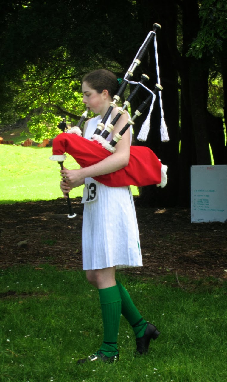
Some of the young people have multiple skills, competing in several categories. I watched one young woman in Irish dancing costume playing the bagpipes for a judge, having just been placed 2nd in Irish Dancing. Later I saw the same girl dancing in another Irish item, which required the most amazing stamina, calf muscle strength, and memory. And later again, I saw her performing a Highland dance, having changed her costume to a kilt and velvet jacket.


A gifted, multi-talented young woman plays the bagpipes before a judge

At midday, competitions stopped for the lunch break. To entertain the crowds, there was a performance by the Kapiti Coast Pipes and Drums Band. They marched onto the lawn in front of the stage, and formed a circle to play number of stirring tunes. I noticed that only the pipers had feathers in their caps, the drummers just had little red pompoms on top. I wonder why? I also noticed that the drummers had to wear their sporrans pushed to the back, because they would otherwise get in the way of their drums.


The Kapiti Coast Pipes and Drums (photo by John)


The drummers are twirling their drumsticks aloft

After the band had marched off into the distance, it was the turn of six members of the Upper Hutt Scottish Country Dance Club to demonstrate some dances. They performed four dances, on the grass. In between dances the leader (and teacher of the club) spoke about the dances, and about SCD in general, inviting anyone who would be interested in finding out more, to join them for their classes on Wednesday nights.


Members of the Upper Hutt SCD club dance a strathspey called “The Minister on the Loch”

We stayed to watch a little bit of the tug of war, then headed off, over the hill to Greytown and some lunch.


The tug of war (photo by John)

After lunch we cycled the Greytown to Woodside Rail Trail. Parts of the trail looked quite different from when we rode here in August. Back then, being winter, all the trees were bare, but now they were all wonderfully green. The young trees near the beginning of the trail, which in August were mere sticks, and which I thought were cherry trees, turned out in fact to be poplars, and they had grown considerably in the past few months.


The beautiful oak trees were in full leaf


I like this view of the path skirting the paddocks (photo by John)

It didn’t take us very long to get to the Woodside Station. This time, instead of going up to the new station, we took the track on the other side of the railway line, towards the old derelict station. When the new station was built, the old one was used as a storage shed for some years. But now it's been abandoned to the elements.


Vegetation tries to overwhelm the derelict old station building (photo by John)

Inside the old building, nature has tried to take over, with grass growing in gaps in the concrete floor, and the aerial roots of the creeper that is growing up to and into the roof, hanging from the rafters.


Inside the old building, grass grows in the gaps in the concrete (photo by John)


Aerial roots of a creeper hang from the rafters (photo by John)

The old and the new stations – basically the same design

On the way back I spotted some alpacas (or are they llamas?) in a paddock near a house. I had to peer through the trees to be able to take a picture of them.


Alpacas – or are they llamas?

These trees don’t look anything like “whomping trees” anymore now that they are in full leaf (refer to my Greytown post of 18 August) (photo by John)

It was a nice short ride, only 10kms, done in less than an hour, but just enough to keep us occupied before we checked into the motel we had booked in Carterton. The motel wasn’t anything to write home about – plain, very 1970s décor, fake Spanish hacienda. But it was clean, and the host was very pleasant.

It was still sunny so we found a place to sit by the motel’s pool. The area had obviously not yet been prepared for summer, as the water in the pool was a murky green and there was all sorts of debris floating on the top. But no matter, there were some chairs there and we sat in the sun with our orange juice, chippies and books for a while.

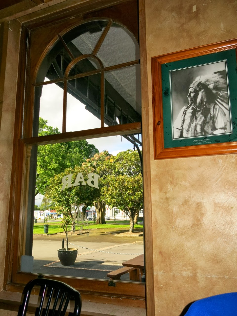
Before heading to the dance, we had dinner at the Carterton pub, “Buckhorn Bar and Grill”, where we had a very generously sized and reasonably priced meal. The interior of the pub had a Wild West theme, with photos of Indians and cowboys, posters of rifles and handguns of the era, and photos of Western movie stars.


Inside the “Buckhorn Bar and Grill” (photo by John)

Carterton’s Memorial Square in the late afternoon sun (photo by John)

The dance was very well attended, with more than 50 people there, many of them visitors from Wellington, Hawke’s Bay, Rangitikei and even Wanganui.


The dance was well attended and everyone had a great time (photo by John)


On Sunday morning we parked the car in a side street and rode all around the side and back streets of Greytown. It is such a pretty township with lovely houses and gardens in tree-lined streets.


A delightful rose-covered cottage

Beautiful tree-lined streets (photo by John)

Riding on the roads was not a problem, as there was virtually no traffic, and it was all on the flat. I would think that for people like me, who don't like to risk having to compete with fast-moving traffic, the back streets of many NZ country towns would be a good alternative to dedicated cycling trails. And it is a good way to get to know a town, too.


Another gorgeous street (photo by John)

The township is not very large, and soon we were riding around the rural perimeter of the town. Here the new houses were set well back from the roadside, on rather large sections. If you were wanting a semi-rural lifestyle, this would be ideal – provided you had the funds, of course.

Along this road on the edge of town, large modern houses on huge sections are hidden from view behind the trees (photo by John)

At the end of Udy Street, we came to a gate and a sign saying Walkway/ Cycleway/ Nature Trail. So of course we wanted to try it out. But first we said hello to a horse by the fence. While we were doing so, I was amused to see a rooster come rushing over to us. He must have been thinking that if the horse was going to be given something nice to eat, he wanted some too! He was in such a hurry, he kept tripping himself up in the long grass! Quite comical.


A beautiful rooster rushed over to see if we had anything to offer

The cycleway really wasn’t very good to ride on. It was very rough and bumpy, and in places the gravel was deep and skiddy. It didn’t go very far though, because we soon got to the Waiohine River. I believe there are plans – long-term plans, perhaps – to join up this track with the Woodside trail to create a full loop. That would make a really lovely ride, especially if it would run beside the river some of the way.


Cycleway leading to the Waiohine River

The Waiohine River (photo by John)

The way back into the town led down some lovely lanes. Through a gap in a hedge, I spotted some sheep resting in the shade of some trees. I thought that would make a lovely peaceful picture, but as I pulled up and carefully approached the fence, one lot looked at me in alarm and got up, ready to run. Silly things. Fortunately, the ones under another tree, a bit further away stayed put, so I did get my peaceful, bucolic photo.


Sheep resting in the shade of a tree

I love the regularity of these trees and fence posts

We cycled pretty much all of the back streets on both sides of the main road, and clocked up 22 kms. We were intrigued by signs pointing this way or that, saying “Rug Sale”. The signs were everywhere, but we never actually came across the place where the rug sale was.

By about 1:30 pm, we thought it was time to stop for lunch, so we headed towards Martinborough to look for a winery with a café. We found what we wanted at the Margrain Vineyard Café. A lovely setting with tables scattered on the lawn overlooking the vines. We chose a table in the semi-shade of some large trees, as it was getting quite warm in the sun.


Lunch at the Margrain Vineyard Café (photo by John)

The vines

Lunch was very satisfying, and the glass of Riesling was so delicious that we stopped at the winery shop afterwards to buy a couple of bottles to take home.

After a leisurely lunch and yummy dessert, we went for a bike ride around the vines, circumnavigating Martinborough and finally through the square. We rode about five kilometres, which was enough, because by now a brisk breeze had sprung up and made the going a little harder.

Finally we walked around the Martinborough town centre, browsing the shops. Parked outside one of the shops was a magnificent motorbike, which had several admiring males around it – practically salivating … Of course John had to take a picture of it. It was a beautiful looking machine, I must say, but I’m happy with my bike, thank you.

This beautiful motorcycle stopped several men in their tracks (photo by John)