Showing posts with label Mana. Show all posts

Wednesday, 4 October 2017

Mana to Pauatahanui


On Monday 11 September, it was a fine but windy day, so we decided on a short-ish, undemanding ride (17 km). We hadn’t biked to Pauatahanui for quite a while, so we parked at the Ngati Toa Domain, in Mana, and biked along the Camborne Walkway. The track was reasonably dry, and we didn’t encounter any people with pushchairs, so I ‘survived’ the track without taking a spill – as I did the last time we were here.

On the Camborne Walkway (photo by John)

We biked to Pauatahanui and had lunch at the Ground Up Café. We are always impressed with how quickly our coffees are delivered – the barista must be listening closely to the orders being placed, and putting them into effect immediately.

John’s hotcakes were beautifully presented – and delicious too (photo by John)

After lunch we looked into the saddlery and stock feed shop next door, and got talking to the young woman at the counter. She was interested in our SmartMotion bikes, as she said she worked a couple of days a week for Daryl Neal, from whom we bought these bikes, when he used to own Wellington Electric Bikes in Upper Hutt. He had a hand in designing the SmartMotions, but now concentrates on designing and building UBCO electric farmbikes, and she works on his web design. Thinking she would be a keen cyclist, I asked her what sort of bike she rode. Her answer was “I ride a horse”!

On the way back along Motukaraka Point, I noticed a layer of shells in the cut-away bank next to the road – a midden from long ago. This area was once an important Ngati Ira settlement. While John stopped to take a photo of it, we were hailed by a chap who had been sitting near his parked car, playing his ukulele. “I know you, do you write a blog? I recognised your bikes”. He said his name was Terry Casey, and he plays in Bluegrass bands in Upper Hutt pubs. We chatted, and then he played a little tune on his mouth organ. You do meet some interesting people while biking …

There are some nice gardens at Motukaraka Point (photo by John)

A midden – this area was once an important Māori settlement (photo by John)

A chat with Terry Casey, Bluegrass musician (photo by John)

There is a new stretch of track and boardwalk across some of the wetlands, which is very much nicer to ride on than the road (which is narrow and busy wih car traffic). It is a local Rotary project, and I hope that eventually the whole stretch between Motukaraka and the Camborne Walkway will be provided with a walking/cycle track away from the road.

The boardwalk across the tidal area (photo by John)

The tide was in and the wind was quite strong, causing wavelets to slap onto the road (photo by John)

Back at the Ngati Toa Domain, we thought we would go and look at the “beach that disappeared”. In April, a whole beach alongside the Mana Marina disappeared overnight. In the aerial photo on this website,  you can see the same brown yacht as in John’s photo, and you can see how large the beach was, which is now gone.

There was once a beach here … (photo by John)

A final pretty shot of the entrance to Porirua Harbour (photo by John)


Saturday, 24 June 2017

Mana to Pukerua


Last Monday, 19 June, we took a ride from Mana to Pukerua Bay. It was fine but cold, however there was little wind. We parked the car at the Ngati Toa Domain in Mana, and biked along the foreshore to Plimmerton.

The rocky foreshore, looking across to the Whitireia Peninsula and Mana Island beyond (photo by John)

Looking the other way, towards Plimmerton (photo by John)

We biked up Te Ara Harakeke from Plimmerton to Pukerua, where we used the pedestrian overbridge to cross SH1, so we could explore the “other” side of Pukerua. We have lived in Wellington for over 50 years, and have driven through Pukerua a gazillion times, but we had never explored that area.

After crossing the railway line at the station, we headed to the left, towards a track that looked promising. However it was the track leading to the Escarpment Track. This is the steep 10 km track that clings to the side to the Paekakariki Hill. It was opened last year, and is part of the Te Araroa Walking Trail which runs the length of New Zealand, 3,000 km, from Cape Reinga to Bluff.

While I am full of admiration (no, actually, I think they're completely bonkers!) for the many people who are bold and keen enough to walk this track, there is no way at all that I will ever attempt it. Not on foot, and not by bike (which is not possible anyway). I stick to the assertion that I am a “flatlander” – I don’t “do hills” if I can help it.

The sign at the start of the Escarpment Track is full of warnings (click to enlarge), but it doesn’t seem to put off hundreds of people who enjoy walking it – but it’s not for me! (photo by John)

This part of Pukerua Bay is a pleasant suburban area, where some of the streets have gorgeous views out towards Paraparaumu and the Tasman Sea.

Some streets had great views (photo by John)

We came across a house which was a work of art in progress. Three-quarters of the façade had been painted with a view, which I imagine will be like the view they get from the windows on the other side of the house. Or perhaps, as John suggests, it could be the view one gets from Plimmerton. The lower right quadrant is yet to be painted. We will have to come back next summer to see if it has been completed.

The painted house (photo by John)

We biked all around the streets, and arrived at the old, now closed, Muri Station. The Escarpment Track skirts this area. We continued on the path alongside the station, but it petered out at a grassy slope, and we ended up pushing our bikes up it (thank goodness for the “walk assist” on our bikes) to get back to the street above.

After a good explore around the streets, we saw that clouds were gathering, and we didn’t want to get caught in the rain, so we headed back. We stopped at Plimmerton’s Big Salami Café for coffee and one of their delicious pizzas. We’d had a pleasant ride, exploring a "new" area, and John had managed it OK, despite some health concerns a few days earlier. We had done 22 km.

The foreshore track between Plimmerton and Mana (photo by John)


Tuesday, 3 November 2015

Tawa to Plimmerton


On a fine Saturday last week (24 October), we biked from Tawa to Plimmerton and back. We again parked at Takapu Road railway station. John suggested we could bike from home, but I am still a bit worried about biking on Middleton Road (see postscript below), which has either a very narrow shoulder or none at all, and there is a reasonable amount of car traffic using that road with the speed limit being 70 km/hr on the most winding part!

We biked the same route as we had a couple of weeks earlier, taking time to linger near the Mana Marina area for a bit. We discovered that recently, a garden area near the yacht jetties had been “embellished” by the display of a number of colourful garden gnomes – one of them, gruesomely, lying face down with a knife in his back!

Miscellaneous rides


Here I am. I need to do some catching up.

We did a couple of rides without taking any photos. One was a local “errands ride”, to the Resene shop in Johnsonville, then to our local café in Middleton Road, and home via the supermarket. Not very exciting, but good to be able to do these things without using the car.

Tawa to Mana


On Sunday 11 October, we started out from Takapu Road station. Being a weekend, there was plenty of parking there. We biked on Te Ara Tawa, beside the railway line and through Linden to Porirua. The only photo we took was of a little waterfall in the Porirua Stream, where a shag (cormorant) was sunning itself on a rock.You'll need to click on the photo to enlarge it if you want to see the shag ...

Porirua Stream near the Linden sportsground (photo by John)

We carried on towards Aotea, past the Aotea Lagoon and the Police College. Across the footbridge at the Paremata railway station, and on towards Mana, where we stopped for lunch at Café Ruby. It was a sunny afternoon and the café was busy, so we were there for quite a while.

Back the way we came, and at the new subdivision of Aotea, we decided to explore the new streets for a bit. We are looking to have our house re-roofed and painted, so we were interested to see the various treatments and colour schemes in the new houses. We also stopped and looked into a couple of the half dozen show homes that were open for viewing. Very nice!

We did about 32 km on this ride.

                                                  * * * * * * * * * * * *

Miramar Peninsula


On Tuesday 20 October, a lovely calm day, we decided to do another ride to the Ataturk Memorial, high up on the Miramar Peninsula. We parked the car at Greta Point, and biked around Evans Bay and Cobham Drive to Miramar, from where we headed uphill. Last time we got ourselves a bit confused and had trouble finding Bowes Crescent from where we could get access to the Ataturk Memorial. No such problems today.

The memorial reserve sits on a steep promontory above Tarakena Bay, looking out to Cook Strait. On a bright sunny day like this, its white cylinder stands out sharply against the blue sea.
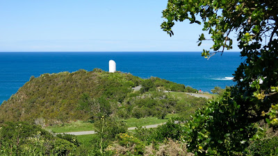
The Ataturk Memorial looks out over Cook Strait (photo by John)

At the memorial (photo by John)

The last time we were up here, there was a terrific southerly swell, and the waves created a chevron of foam as they rolled in from both sides onto the rocks off the headland. This time, however, the view was peaceful and we revelled in the beautiful colours of the water.

The seas around the rocks were beautifully calm (photo by John)

After an interesting chat with a couple from Auckland, we biked down the wide track to Moa Point Road, and rode around the peninsula to Breaker Bay. We stopped at the carpark near the beach for a closer look at the rocks. In the distance we could see Steeple Rock, which is near where the Interisland ferry Wahine sank in 1968.

The rocks at Breaker Bay, with Steeple Rock in the top one-third of the photo (photo by John)

Looking across the harbour entrance to the Pencarrow Lighthouse.
You can see Barrett Reef – the cause of the sinking of the Wahine (photo by John)

After the Pass of Branda – which sounds worse than it is – we rode through the suburb of Seatoun, round Worser Bay, and to Scorching Bay, where we had lunch at the Scorch-O-Rama Café.

A pleasant ride around the rest of the peninsula took us back to our car. We had done 26 km.


Friday, 6 March 2015

Tawa to Mana


Last Saturday we took the e-bikes for a ride from Tawa to Mana, via Porirua and Aotea. We started our ride at Takapu Road train station, and followed Te Ara Tawa. There was a brisk northerly wind, so I was rather glad we had taken the e-bikes. Stupidly though, I didn’t use my gears properly, so despite the e-assist level set at 2, I found the going a bit sluggish. It wasn’t until we were past Porirua that I ‘twigged’ that I should be using a lower gear. Duh!

The nice smooth track of Ara Tawa ends at the Kenepuru station, and then there is a choice of either riding on the main road through Kenepuru, or continuing on the rough gravel track alongside the railway line. We took the gravel track and I hated it. It was very rough, and hard on my hands.

When we got to Porirua, we continued on a concrete path on the right hand side of the Porirua Stream, which we thought would take us to the bridge over the motorway. But instead we ended up going over a lovely little swing bridge, which ended up nowhere – the path beyond it petered out to a grassy track that was not bikeable.

A nice little bridge, but it led to nowhere!

So we turned back down the concrete path till it went under a road bridge, and from there we were able to get to the track on the other side of the stream. A bit further on was the bridge over the motorway, leading to the new suburb of Aotea.

We had to go under and then over this bridge, to get to the next bridge in the distance (photo by John)

Now that the Aotea subdivision has taken off, the path to get there from Porirua is much improved since we rode there the very first time, over a year ago. It is now wide and sealed, with a thin layer of smooth gravel. Much nicer.

The path between Porirua and Aotea, looking towards Porirua (photo by John)

Up to Aotea, past the Aotea Lagoon, and along Papakowhai Road. We crossed over the motorway and the railway line by climbing up over the overbridge which ended us up by the Paremata Station. From there we ducked under the railway line through the underpass to get to the Paremata Bridge. It sounds rather involved when it's written down, but it was simpler than having to negotiate the road crossings at the Paremata Roundabout.

Whizzing to the top by using the throttle of the e-bike was very satisfying! (photo by John)

Once across the Paremata Bridge, we pedalled along to Café Ruby in Mana for coffee and a scone. The return trip was straightforward. We didn’t use the rough track along the railway line, but rode on the road between Porirua and Kenepuru, before getting back onto Ara Tawa. We rode 27 km.